Doğanpınar geodata
Doğanpınar (Gaziantep) is a seat of a third-order administrative division; located in Turkey in Europe/Istanbul (GMT+3) time zone. With population of 908 people, there are 1116 cities with bigger population in this country. Compared to other cities in Turkey, 92.2% of cities are located further ↑North; 59.5% of cities are located further ←West and 55.5% of cities have higher elevation than Doğanpınar. Note1


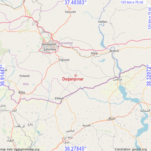
Doğanpınar GPS coordinates[2]
36° 50' 35.556" North, 37° 37' 3.324" East
| Map corner | latitude | longitude |
|---|---|---|
| Upper-left | 37.40383°, | 36.91447° |
| Center: | 36.84321°, | 37.61759° |
| Lower-right: | 36.27845°, | 38.32072° |
| Map W x H: | 125.1×125.1 km | = 77.7×77.7mi |
| max Lat: | 42.02683° ⇑92.2% North |
| Doğanpınar: | 36.84321° |
| min Lat: | ⇓7.8% South 35.9025° |
| min Long | Doğanpınar | max Long |
| 25.90902° | 37.61759° | 44.60099° |
| W 59.5%⇐ | ⇒40.5% E |
Elevation
Elevation of Doğanpınar is 578 m = 1896 ft, and this is 139.4 m = 457 ft below average elevation for this country.
| Max E: |
2682 m = 8799 ft | 55.5% |
| Avg. | 717.4 m = 2354 ft | |
| Doğanpınar | 578 m = 1896 ft | |
Min E: |
0 m = 0 ft | 44.5% |
See also: Turkey elevation on elevation.city.
Geographical zone
Doğanpınar is located in North temperate zone (between Tropic of Cancer and the Arctic Circle). Distance of this Northern Tropic circle is 1490.7 km =926.3 mi to South.| Distance of | km | miles | from Doğanpınar |
|---|---|---|---|
| North Pole | 5910.5 | 3672.6 | to North |
| Arctic Circle | 3304.6 | 2053.4 | to North |
| Tropic Cancer | 1490.7 | 926.3 | to South |
| Equator | 4096.6 | 2545.5 | to South |


Nearby cities:
15 places around Doğanpınar: (largest is in red/bold)
• Aşağıbeylerbeyi
18.6 km =11.6 mi,  207°
207°
• Büyükkaracaören
11 km =6.8 mi,  216°
216°
• Elbeyli
23.1 km =14.4 mi, 215°
• Gevence
21.6 km =13.4 mi,  69°
69°
• Gündoğan
7.3 km =4.5 mi,  300°
300°
• Kirap
8.7 km =5.4 mi,  61°
61°
• Oğuzeli
16.5 km =10.3 mi,  325°
325°
• Sekili
15.8 km =9.8 mi,  17°
17°
• Uluyatır
15 km =9.3 mi,  26°
26°
• Yakacık
8.9 km =5.5 mi,  311°
311°
• Yeserti
20.4 km =12.7 mi,  87°
87°
• Yeşildere
18.1 km =11.2 mi,  322°
322°
• Zeytinli
21.1 km =13.1 mi, 304°
• Çiflikköy
16 km =9.9 mi,  96°
96°
• İkizce
14.1 km =8.8 mi,  81°
81°
Sources, notices
• [Note1] Compared only with cities in Turkey existing in our database
• [Src1] Map data: © OpenStreetMap contributors (CC-BY-SA)
• [Src2] Other city data from geonames.org with taken over terms of usage.
• [Src3] Geographical zone / Annual Mean Temperature by Robert A. Rohde @ Wikipedia
