Oğuzeli geodata
Oğuzeli (Gaziantep) is a seat of a second-order administrative division; located in Turkey in Europe/Istanbul (GMT+3) time zone. With population of 11,527 people, there are 465 cities with bigger population in this country. Compared to other cities in Turkey, 88.9% of cities are located further ↑North; 58.9% of cities are located further ←West and 50.3% of cities have higher elevation than Oğuzeli. Note1


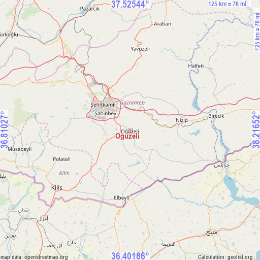
Oğuzeli GPS coordinates[2]
36° 57' 56.592" North, 37° 30' 48.204" East
| Map corner | latitude | longitude |
|---|---|---|
| Upper-left | 37.52544°, | 36.81027° |
| Center: | 36.96572°, | 37.51339° |
| Lower-right: | 36.40186°, | 38.21652° |
| Map W x H: | 124.9×124.9 km | = 77.6×77.6mi |
| max Lat: | 42.02683° ⇑88.9% North |
| Oğuzeli: | 36.96572° |
| min Lat: | ⇓11.1% South 35.9025° |
| min Long | Oğuzeli | max Long |
| 25.90902° | 37.51339° | 44.60099° |
| W 58.9%⇐ | ⇒41.1% E |
Elevation
Elevation of Oğuzeli is 688 m = 2257 ft, and this is 29.4 m = 96 ft below average elevation for this country.
| Max E: |
2682 m = 8799 ft | 50.3% |
| Avg. | 717.4 m = 2354 ft | |
| Oğuzeli | 688 m = 2257 ft | |
Min E: |
0 m = 0 ft | 49.7% |
See also: Turkey elevation on elevation.city.
Geographical zone
Oğuzeli is located in North temperate zone (between Tropic of Cancer and the Arctic Circle). Distance of this Northern Tropic circle is 1504.3 km =934.7 mi to South.| Distance of | km | miles | from Oğuzeli |
|---|---|---|---|
| North Pole | 5896.9 | 3664.2 | to North |
| Arctic Circle | 3291 | 2044.9 | to North |
| Tropic Cancer | 1504.3 | 934.7 | to South |
| Equator | 4110.2 | 2554 | to South |


Nearby cities:
15 places around Oğuzeli: (largest is in red/bold)
• Büyükkaracaören
22.6 km =14 mi,  173°
173°
• Doğanpınar
16.5 km =10.3 mi,  145°
145°
• Gaziantep
15.6 km =9.7 mi,  311°
311°
• Gündoğan
10.3 km =6.4 mi,  163°
163°
• Kirap
19.4 km =12.1 mi,  119°
119°
• Nizip
25.4 km =15.8 mi,  78°
78°
• Sekili
14.1 km =8.8 mi, 84°
• Uluyatır
16 km =9.9 mi,  90°
90°
• Yakacık
8.2 km =5.1 mi, 161°
• Yeşildere
1.8 km =1.1 mi,  296°
296°
• Zeytinli
8.2 km =5.1 mi,  259°
259°
• Çiflikköy
29.5 km =18.3 mi, 121°
• İkizce
25.9 km =16.1 mi, 116°
• Şahinbey
17.6 km =10.9 mi, 301°
• Şehitkamil
17.3 km =10.7 mi,  316°
316°
Sources, notices
• [Note1] Compared only with cities in Turkey existing in our database
• [Src1] Map data: © OpenStreetMap contributors (CC-BY-SA)
• [Src2] Other city data from geonames.org with taken over terms of usage.
• [Src3] Geographical zone / Annual Mean Temperature by Robert A. Rohde @ Wikipedia
