Yeşildere geodata
Yeşildere (Gaziantep) is a populated place; located in Turkey in Europe/Istanbul (GMT+3) time zone. With population of 2,701 people, there are 881 cities with bigger population in this country. Compared to other cities in Turkey, 88.7% of cities are located further ↑North; 58.7% of cities are located further ←West and 50.8% of cities have lower elevation than Yeşildere. Note1


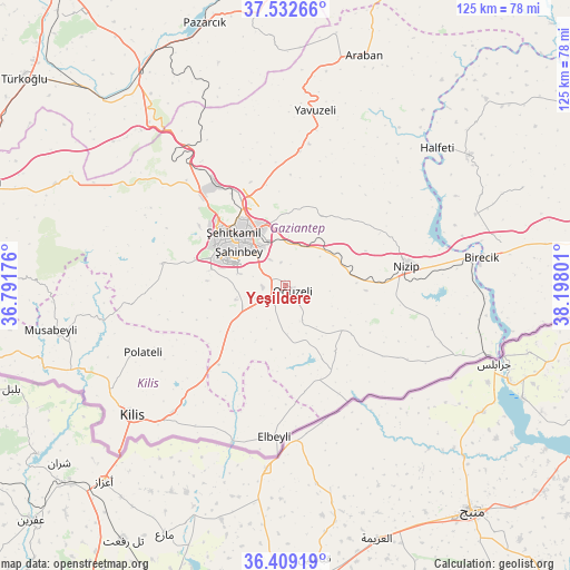
Yeşildere GPS coordinates[2]
36° 58' 22.8" North, 37° 29' 41.568" East
| Map corner | latitude | longitude |
|---|---|---|
| Upper-left | 37.53266°, | 36.79176° |
| Center: | 36.973°, | 37.49488° |
| Lower-right: | 36.40919°, | 38.19801° |
| Map W x H: | 124.9×124.9 km | = 77.6×77.6mi |
| max Lat: | 42.02683° ⇑88.7% North |
| Yeşildere: | 36.973° |
| min Lat: | ⇓11.3% South 35.9025° |
| min Long | Yeşildere | max Long |
| 25.90902° | 37.49488° | 44.60099° |
| W 58.7%⇐ | ⇒41.3% E |
Elevation
Elevation of Yeşildere is 709 m = 2326 ft, and this is 8.4 m = 28 ft below average elevation for this country.
| Max E: |
2682 m = 8799 ft | 49.2% |
| Avg. | 717.4 m = 2354 ft | |
| Yeşildere | 709 m = 2326 ft | |
Min E: |
0 m = 0 ft | 50.8% |
See also: Turkey elevation on elevation.city.
Geographical zone
Yeşildere is located in North temperate zone (between Tropic of Cancer and the Arctic Circle). Distance of this Northern Tropic circle is 1505.1 km =935.2 mi to South.| Distance of | km | miles | from Yeşildere |
|---|---|---|---|
| North Pole | 5896 | 3663.6 | to North |
| Arctic Circle | 3290.2 | 2044.4 | to North |
| Tropic Cancer | 1505.1 | 935.2 | to South |
| Equator | 4111 | 2554.5 | to South |


Nearby cities:
15 places around Yeşildere: (largest is in red/bold)
• Burç
28.4 km =17.6 mi,  279°
279°
• Büyükkaracaören
23.6 km =14.7 mi,  169°
169°
• Doğanpınar
18.1 km =11.2 mi,  142°
142°
• Gaziantep
13.9 km =8.6 mi,  313°
313°
• Gündoğan
11.7 km =7.3 mi,  156°
156°
• Kirap
21.2 km =13.2 mi,  119°
119°
• Nizip
26.9 km =16.7 mi,  81°
81°
• Oğuzeli
1.8 km =1.1 mi, 116°
• Sekili
15.7 km =9.8 mi,  87°
87°
• Uluyatır
17.7 km =11 mi, 93°
• Yakacık
9.6 km =6 mi,  153°
153°
• Zeytinli
6.9 km =4.3 mi,  249°
249°
• İkizce
27.7 km =17.2 mi, 116°
• Şahinbey
15.8 km =9.8 mi,  301°
301°
• Şehitkamil
15.6 km =9.7 mi,  319°
319°
Sources, notices
• [Note1] Compared only with cities in Turkey existing in our database
• [Src1] Map data: © OpenStreetMap contributors (CC-BY-SA)
• [Src2] Other city data from geonames.org with taken over terms of usage.
• [Src3] Geographical zone / Annual Mean Temperature by Robert A. Rohde @ Wikipedia
