Zeytinli geodata
Zeytinli (Gaziantep) is a populated place; located in Turkey in Europe/Istanbul (GMT+3) time zone. With population of 600 people, there are 1252 cities with bigger population in this country. Compared to other cities in Turkey, 89.3% of cities are located further ↑North; 58.3% of cities are located further ←West and 51.8% of cities have lower elevation than Zeytinli. Note1


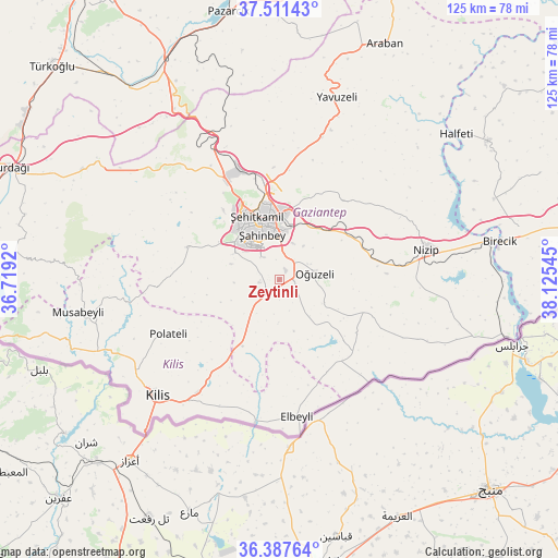
Zeytinli GPS coordinates[2]
36° 57' 5.796" North, 37° 25' 20.352" East
| Map corner | latitude | longitude |
|---|---|---|
| Upper-left | 37.51143°, | 36.7192° |
| Center: | 36.95161°, | 37.42232° |
| Lower-right: | 36.38764°, | 38.12545° |
| Map W x H: | 125×125 km | = 77.7×77.7mi |
| max Lat: | 42.02683° ⇑89.3% North |
| Zeytinli: | 36.95161° |
| min Lat: | ⇓10.7% South 35.9025° |
| min Long | Zeytinli | max Long |
| 25.90902° | 37.42232° | 44.60099° |
| W 58.3%⇐ | ⇒41.7% E |
Elevation
Elevation of Zeytinli is 735 m = 2411 ft, and this is 17.6 m = 58 ft above average elevation for this country.
| Max E: |
2682 m = 8799 ft | 48.2% |
| Zeytinli | 735 m 2411 ft | |
| Avg. | 717.4 m = 2354 ft | |
Min E: |
0 m = 0 ft | 51.8% |
See also: Turkey elevation on elevation.city.
Geographical zone
Zeytinli is located in North temperate zone (between Tropic of Cancer and the Arctic Circle). Distance of this Northern Tropic circle is 1502.7 km =933.7 mi to South.| Distance of | km | miles | from Zeytinli |
|---|---|---|---|
| North Pole | 5898.4 | 3665.1 | to North |
| Arctic Circle | 3292.5 | 2045.9 | to North |
| Tropic Cancer | 1502.7 | 933.7 | to South |
| Equator | 4108.6 | 2553 | to South |


Nearby cities:
15 places around Zeytinli: (largest is in red/bold)
• Burç
22.7 km =14.1 mi,  287°
287°
• Büyükkaracaören
23.5 km =14.6 mi,  152°
152°
• Doğanpınar
21.1 km =13.1 mi,  124°
124°
• Gaziantep
12.5 km =7.8 mi,  343°
343°
• Güldüzü
28.7 km =17.8 mi,  251°
251°
• Gündoğan
13.9 km =8.6 mi,  126°
126°
• Kirap
26.3 km =16.3 mi,  107°
107°
• Oğuzeli
8.2 km =5.1 mi,  79°
79°
• Polateli
27.6 km =17.1 mi,  243°
243°
• Sekili
22.4 km =13.9 mi, 82°
• Uluyatır
24.1 km =15 mi,  86°
86°
• Yakacık
12.3 km =7.6 mi, 120°
• Yeşildere
6.9 km =4.3 mi,  69°
69°
• Şahinbey
12.8 km =8 mi,  327°
327°
• Şehitkamil
14.7 km =9.1 mi,  345°
345°
Sources, notices
• [Note1] Compared only with cities in Turkey existing in our database
• [Src1] Map data: © OpenStreetMap contributors (CC-BY-SA)
• [Src2] Other city data from geonames.org with taken over terms of usage.
• [Src3] Geographical zone / Annual Mean Temperature by Robert A. Rohde @ Wikipedia
