Kavaklıdere geodata
Kavaklıdere (Muğla) is a seat of a second-order administrative division; located in Turkey in Europe/Istanbul (GMT+3) time zone. With population of 3,466 people, there are 823 cities with bigger population in this country. Compared to other cities in Turkey, 76.3% of cities are located further ↑North; 87.9% of cities are located further →East and 61% of cities have lower elevation than Kavaklıdere. Note1


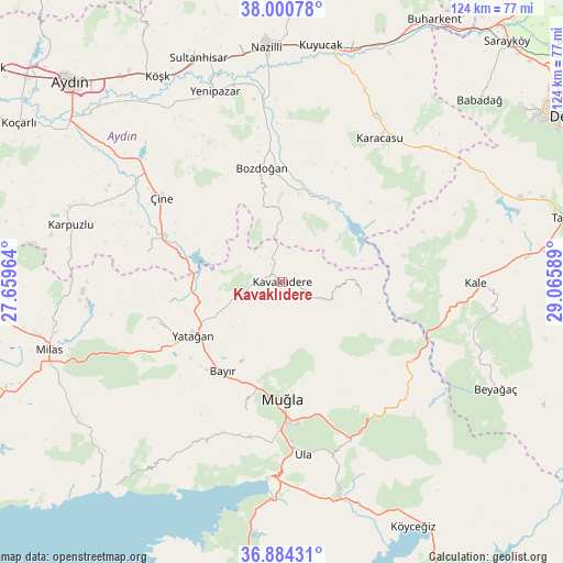
Kavaklıdere GPS coordinates[2]
37° 26' 40.668" North, 28° 21' 45.936" East
| Map corner | latitude | longitude |
|---|---|---|
| Upper-left | 38.00078°, | 27.65964° |
| Center: | 37.44463°, | 28.36276° |
| Lower-right: | 36.88431°, | 29.06589° |
| Map W x H: | 124.1×124.1 km | = 77.1×77.1mi |
| max Lat: | 42.02683° ⇑76.3% North |
| Kavaklıdere: | 37.44463° |
| min Lat: | ⇓23.7% South 35.9025° |
| min Long | Kavaklıdere | max Long |
| 25.90902° | 28.36276° | 44.60099° |
| W 12.1%⇐ | ⇒87.9% E |
Elevation
Elevation of Kavaklıdere is 897 m = 2943 ft, and this is 179.6 m = 589 ft above average elevation for this country.
| Max E: |
2682 m = 8799 ft | 39% |
| Kavaklıdere | 897 m 2943 ft | |
| Avg. | 717.4 m = 2354 ft | |
Min E: |
0 m = 0 ft | 61% |
See also: Turkey elevation on elevation.city.
Geographical zone
Kavaklıdere is located in North temperate zone (between Tropic of Cancer and the Arctic Circle). Distance of this Northern Tropic circle is 1557.5 km =967.8 mi to South.| Distance of | km | miles | from Kavaklıdere |
|---|---|---|---|
| North Pole | 5843.6 | 3631 | to North |
| Arctic Circle | 3237.7 | 2011.8 | to North |
| Tropic Cancer | 1557.5 | 967.8 | to South |
| Equator | 4163.5 | 2587.1 | to South |


Nearby cities:
15 places around Kavaklıdere: (largest is in red/bold)
• Akçaova
30.4 km =18.9 mi,  282°
282°
• Bayır
23.5 km =14.6 mi,  213°
213°
• Bozarmut
22.8 km =14.2 mi,  228°
228°
• Bozdoğan
25.6 km =15.9 mi,  350°
350°
• Göktepe
17.6 km =10.9 mi,  99°
99°
• Kale
42.6 km =26.5 mi,  90°
90°
• Karacasu
38.1 km =23.7 mi,  34°
34°
• Menteşe
37.4 km =23.2 mi,  193°
193°
• Muğla
25.2 km =15.7 mi,  179°
179°
• Turgut
30.3 km =18.8 mi,  255°
255°
• Ula
38.1 km =23.7 mi,  172°
172°
• Yatağan
22.6 km =14 mi,  239°
239°
• Yerkesik
35 km =21.7 mi, 191°
• Yeşilyurt
29 km =18 mi,  195°
195°
• Çine
32.6 km =20.3 mi,  304°
304°
Sources, notices
• [Note1] Compared only with cities in Turkey existing in our database
• [Src1] Map data: © OpenStreetMap contributors (CC-BY-SA)
• [Src2] Other city data from geonames.org with taken over terms of usage.
• [Src3] Geographical zone / Annual Mean Temperature by Robert A. Rohde @ Wikipedia
