Kınık geodata
Kınık (İzmir) is a seat of a second-order administrative division; located in Turkey in Europe/Istanbul (GMT+3) time zone. With population of 10,753 people, there are 490 cities with bigger population in this country. Compared to other cities in Turkey, 55.7% of cities are located further ↓South; 94.3% of cities are located further →East and 83.3% of cities have higher elevation than Kınık. Note1


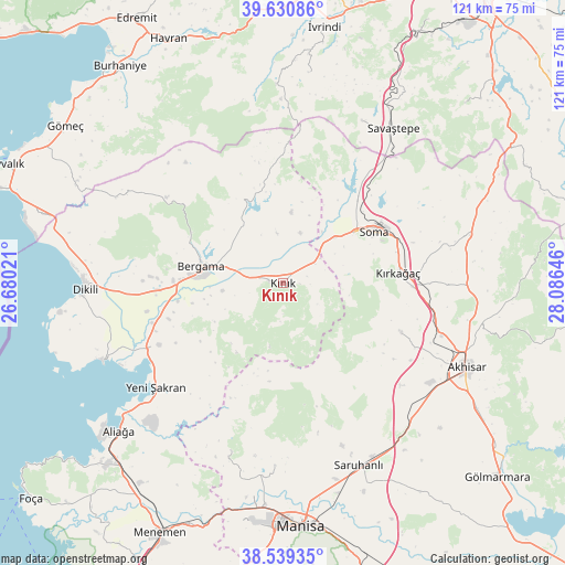
Kınık GPS coordinates[2]
39° 5' 13.992" North, 27° 22' 59.988" East
| Map corner | latitude | longitude |
|---|---|---|
| Upper-left | 39.63086°, | 26.68021° |
| Center: | 39.08722°, | 27.38333° |
| Lower-right: | 38.53935°, | 28.08646° |
| Map W x H: | 121.4×121.4 km | = 75.4×75.4mi |
| max Lat: | 42.02683° ⇑44.3% North |
| Kınık: | 39.08722° |
| min Lat: | ⇓55.7% South 35.9025° |
| min Long | Kınık | max Long |
| 25.90902° | 27.38333° | 44.60099° |
| W 5.7%⇐ | ⇒94.3% E |
Elevation
Elevation of Kınık is 84 m = 276 ft, and this is 633.4 m = 2078 ft below average elevation for this country.
| Max E: |
2682 m = 8799 ft | 83.3% |
| Avg. | 717.4 m = 2354 ft | |
| Kınık | 84 m = 276 ft | |
Min E: |
0 m = 0 ft | 16.7% |
See also: Turkey elevation on elevation.city.
Geographical zone
Kınık is located in North temperate zone (between Tropic of Cancer and the Arctic Circle). Distance of this Northern Tropic circle is 1740.2 km =1081.3 mi to South.| Distance of | km | miles | from Kınık |
|---|---|---|---|
| North Pole | 5661 | 3517.6 | to North |
| Arctic Circle | 3055.1 | 1898.4 | to North |
| Tropic Cancer | 1740.2 | 1081.3 | to South |
| Equator | 4346.1 | 2700.5 | to South |


Nearby cities:
15 places around Kınık: (largest is in red/bold)
• Bergama
17.9 km =11.1 mi,  282°
282°
• Gelembe
41.4 km =25.7 mi,  75°
75°
• Göçbeyli
15.2 km =9.4 mi,  6°
6°
• Kozak
31.2 km =19.4 mi,  305°
305°
• Kırkağaç
24.8 km =15.4 mi,  85°
85°
• Osmancalı
37.8 km =23.5 mi,  197°
197°
• Sarıbeyler
38.4 km =23.9 mi,  25°
25°
• Savaştepe
40.4 km =25.1 mi,  35°
35°
• Soma
22.4 km =13.9 mi,  60°
60°
• Turanlı
21.7 km =13.5 mi,  346°
346°
• Yenişakran
35.3 km =21.9 mi,  230°
230°
• Yuntdağ
22.7 km =14.1 mi,  220°
220°
• Zeytindağ
30 km =18.6 mi,  243°
243°
• Zeytinliova
27.5 km =17.1 mi,  112°
112°
• Üçpınar
39.3 km =24.4 mi,  182°
182°
Sources, notices
• [Note1] Compared only with cities in Turkey existing in our database
• [Src1] Map data: © OpenStreetMap contributors (CC-BY-SA)
• [Src2] Other city data from geonames.org with taken over terms of usage.
• [Src3] Geographical zone / Annual Mean Temperature by Robert A. Rohde @ Wikipedia
