Çukuryurt geodata
Çukuryurt (Batman) is a populated place; located in Turkey in Europe/Istanbul (GMT+3) time zone. With population of 700 people, there are 1200 cities with bigger population in this country. Compared to other cities in Turkey, 72.2% of cities are located further ↑North; 86% of cities are located further ←West and 67.2% of cities have lower elevation than Çukuryurt. Note1


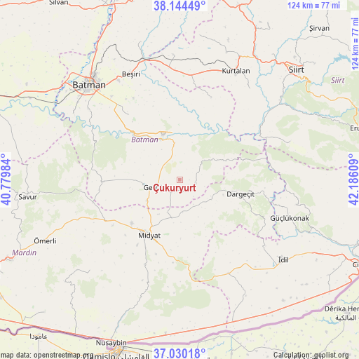
Çukuryurt GPS coordinates[2]
37° 35' 21.912" North, 41° 28' 58.656" East
| Map corner | latitude | longitude |
|---|---|---|
| Upper-left | 38.14449°, | 40.77984° |
| Center: | 37.58942°, | 41.48296° |
| Lower-right: | 37.03018°, | 42.18609° |
| Map W x H: | 123.9×123.9 km | = 77×77mi |
| max Lat: | 42.02683° ⇑72.2% North |
| Çukuryurt: | 37.58942° |
| min Lat: | ⇓27.8% South 35.9025° |
| min Long | Çukuryurt | max Long |
| 25.90902° | 41.48296° | 44.60099° |
| W 86%⇐ | ⇒14% E |
Elevation
Elevation of Çukuryurt is 989 m = 3245 ft, and this is 271.6 m = 891 ft above average elevation for this country.
| Max E: |
2682 m = 8799 ft | 32.8% |
| Çukuryurt | 989 m 3245 ft | |
| Avg. | 717.4 m = 2354 ft | |
Min E: |
0 m = 0 ft | 67.2% |
See also: Turkey elevation on elevation.city.
Geographical zone
Çukuryurt is located in North temperate zone (between Tropic of Cancer and the Arctic Circle). Distance of this Northern Tropic circle is 1573.6 km =977.8 mi to South.| Distance of | km | miles | from Çukuryurt |
|---|---|---|---|
| North Pole | 5827.5 | 3621 | to North |
| Arctic Circle | 3221.6 | 2001.8 | to North |
| Tropic Cancer | 1573.6 | 977.8 | to South |
| Equator | 4179.6 | 2597.1 | to South |


Nearby cities:
15 places around Çukuryurt: (largest is in red/bold)
• Acırlı
22.3 km =13.9 mi,  228°
228°
• Barıştepe
13.8 km =8.6 mi,  210°
210°
• Başyurt
22.8 km =14.2 mi,  141°
141°
• Dargeçit
21.1 km =13.1 mi,  103°
103°
• Derdil
6.3 km =3.9 mi,  6°
6°
• Gerdzhyush
9.8 km =6.1 mi,  252°
252°
• Gökçepınar
3.3 km =2.1 mi,  90°
90°
• Gülveren
11.4 km =7.1 mi,  174°
174°
• Hasankeyf
14.7 km =9.1 mi,  332°
332°
• Hisar
22.5 km =14 mi,  273°
273°
• Karaköy
12.2 km =7.6 mi, 328°
• Kesmeköprü
15.5 km =9.6 mi,  336°
336°
• Kozlu
11.4 km =7.1 mi,  297°
297°
• Ortaca
14.4 km =8.9 mi,  153°
153°
• Yolağzı
13.4 km =8.3 mi,  238°
238°
Sources, notices
• [Note1] Compared only with cities in Turkey existing in our database
• [Src1] Map data: © OpenStreetMap contributors (CC-BY-SA)
• [Src2] Other city data from geonames.org with taken over terms of usage.
• [Src3] Geographical zone / Annual Mean Temperature by Robert A. Rohde @ Wikipedia
