Gökçepınar geodata
Gökçepınar (Batman) is a populated place; located in Turkey in Europe/Istanbul (GMT+3) time zone. With population of 811 people, there are 1145 cities with bigger population in this country. Compared to other cities in Turkey, 72.3% of cities are located further ↑North; 86.4% of cities are located further ←West and 80.9% of cities have lower elevation than Gökçepınar. Note1


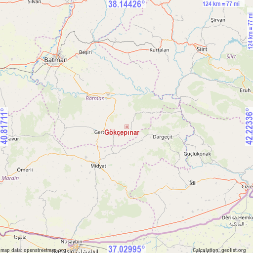
Gökçepınar GPS coordinates[2]
37° 35' 21.084" North, 41° 31' 12.828" East
| Map corner | latitude | longitude |
|---|---|---|
| Upper-left | 38.14426°, | 40.81711° |
| Center: | 37.58919°, | 41.52023° |
| Lower-right: | 37.02995°, | 42.22336° |
| Map W x H: | 123.9×123.9 km | = 77×77mi |
| max Lat: | 42.02683° ⇑72.3% North |
| Gökçepınar: | 37.58919° |
| min Lat: | ⇓27.7% South 35.9025° |
| min Long | Gökçepınar | max Long |
| 25.90902° | 41.52023° | 44.60099° |
| W 86.4%⇐ | ⇒13.6% E |
Elevation
Elevation of Gökçepınar is 1211 m = 3973 ft, and this is 493.6 m = 1619 ft above average elevation for this country.
| Max E: |
2682 m = 8799 ft | 19.1% |
| Gökçepınar | 1211 m 3973 ft | |
| Avg. | 717.4 m = 2354 ft | |
Min E: |
0 m = 0 ft | 80.9% |
See also: Turkey elevation on elevation.city.
Geographical zone
Gökçepınar is located in North temperate zone (between Tropic of Cancer and the Arctic Circle). Distance of this Northern Tropic circle is 1573.6 km =977.8 mi to South.| Distance of | km | miles | from Gökçepınar |
|---|---|---|---|
| North Pole | 5827.5 | 3621 | to North |
| Arctic Circle | 3221.6 | 2001.8 | to North |
| Tropic Cancer | 1573.6 | 977.8 | to South |
| Equator | 4179.5 | 2597 | to South |


Nearby cities:
15 places around Gökçepınar: (largest is in red/bold)
• Barıştepe
15.7 km =9.8 mi,  221°
221°
• Başyurt
20.9 km =13 mi,  148°
148°
• Dargeçit
17.9 km =11.1 mi,  105°
105°
• Derdil
6.8 km =4.2 mi,  337°
337°
• Gerdzhyush
12.9 km =8 mi,  256°
256°
• Gülveren
11.6 km =7.2 mi,  191°
191°
• Hasankeyf
16.5 km =10.3 mi,  321°
321°
• Karaköy
14.2 km =8.8 mi, 317°
• Kesmeköprü
17.1 km =10.6 mi,  326°
326°
• Kozlu
14.4 km =8.9 mi,  291°
291°
• Midyat
24.8 km =15.4 mi, 220°
• Ortaca
13.2 km =8.2 mi,  166°
166°
• Suçatı
21.8 km =13.5 mi,  90°
90°
• Yolağzı
16.3 km =10.1 mi,  244°
244°
• Çukuryurt
3.3 km =2.1 mi,  270°
270°
Sources, notices
• [Note1] Compared only with cities in Turkey existing in our database
• [Src1] Map data: © OpenStreetMap contributors (CC-BY-SA)
• [Src2] Other city data from geonames.org with taken over terms of usage.
• [Src3] Geographical zone / Annual Mean Temperature by Robert A. Rohde @ Wikipedia
