Bahçesaray geodata
Bahçesaray (Van) is a seat of a second-order administrative division; located in Turkey in Europe/Istanbul (GMT+3) time zone. With population of 3,731 people, there are 804 cities with bigger population in this country. Compared to other cities in Turkey, 59.3% of cities are located further ↑North; 95.7% of cities are located further ←West and 96.3% of cities have lower elevation than Bahçesaray. Note1


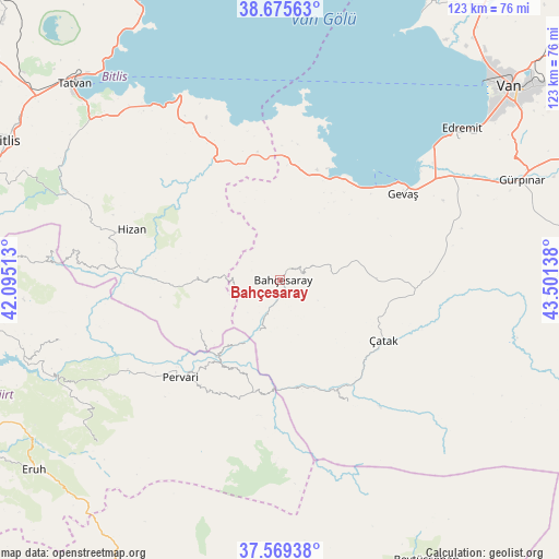
Bahçesaray GPS coordinates[2]
38° 7' 28.56" North, 42° 47' 53.7" East
| Map corner | latitude | longitude |
|---|---|---|
| Upper-left | 38.67563°, | 42.09513° |
| Center: | 38.1246°, | 42.79825° |
| Lower-right: | 37.56938°, | 43.50138° |
| Map W x H: | 123×123 km | = 76.4×76.4mi |
| max Lat: | 42.02683° ⇑59.3% North |
| Bahçesaray: | 38.1246° |
| min Lat: | ⇓40.7% South 35.9025° |
| min Long | Bahçesaray | max Long |
| 25.90902° | 42.79825° | 44.60099° |
| W 95.7%⇐ | ⇒4.3% E |
Elevation
Elevation of Bahçesaray is 1751 m = 5745 ft, and this is 1033.6 m = 3391 ft above average elevation for this country.
| Max E: |
2682 m = 8799 ft | 3.7% |
| Bahçesaray | 1751 m 5745 ft | |
| Avg. | 717.4 m = 2354 ft | |
Min E: |
0 m = 0 ft | 96.3% |
See also: Turkey elevation on elevation.city.
Geographical zone
Bahçesaray is located in North temperate zone (between Tropic of Cancer and the Arctic Circle). Distance of this Northern Tropic circle is 1633.1 km =1014.8 mi to South.| Distance of | km | miles | from Bahçesaray |
|---|---|---|---|
| North Pole | 5768 | 3584.1 | to North |
| Arctic Circle | 3162.1 | 1964.8 | to North |
| Tropic Cancer | 1633.1 | 1014.8 | to South |
| Equator | 4239.1 | 2634.1 | to South |


Nearby cities:
15 places around Bahçesaray: (largest is in red/bold)
• Akşar
23.3 km =14.5 mi,  263°
263°
• Atlıhan
22.9 km =14.2 mi,  174°
174°
• Belenoluk
23.3 km =14.5 mi,  184°
184°
• Beğendik
21.1 km =13.1 mi,  218°
218°
• Gökbudak
27.8 km =17.3 mi,  208°
208°
• Güleçler
29.7 km =18.5 mi,  230°
230°
• Kaçıt
27.3 km =17 mi,  142°
142°
• Narlı
30.9 km =19.2 mi,  149°
149°
• Pervari
30.3 km =18.8 mi, 226°
• Simos
20.2 km =12.6 mi,  248°
248°
• Sözveren
28.7 km =17.8 mi,  121°
121°
• Uzyum
16.1 km =10 mi, 207°
• Yukarı Balcılar
28.9 km =18 mi, 213°
• Çatak
26 km =16.2 mi, 121°
• Övecek
25.7 km =16 mi,  162°
162°
Sources, notices
• [Note1] Compared only with cities in Turkey existing in our database
• [Src1] Map data: © OpenStreetMap contributors (CC-BY-SA)
• [Src2] Other city data from geonames.org with taken over terms of usage.
• [Src3] Geographical zone / Annual Mean Temperature by Robert A. Rohde @ Wikipedia
