Narlı geodata
Narlı (Siirt) is a seat of a third-order administrative division; located in Turkey in Europe/Istanbul (GMT+3) time zone. In our database, there are 1323 cities with bigger population. Compared to other cities in Turkey, 65.7% of cities are located further ↑North; 96.4% of cities are located further ←West and 94.3% of cities have lower elevation than Narlı. Note1


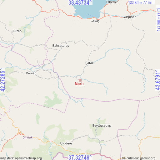
Narlı GPS coordinates[2]
37° 53' 4.164" North, 42° 58' 33.492" East
| Map corner | latitude | longitude |
|---|---|---|
| Upper-left | 38.43734°, | 42.27285° |
| Center: | 37.88449°, | 42.97597° |
| Lower-right: | 37.32746°, | 43.6791° |
| Map W x H: | 123.4×123.4 km | = 76.7×76.7mi |
| max Lat: | 42.02683° ⇑65.7% North |
| Narlı: | 37.88449° |
| min Lat: | ⇓34.3% South 35.9025° |
| min Long | Narlı | max Long |
| 25.90902° | 42.97597° | 44.60099° |
| W 96.4%⇐ | ⇒3.6% E |
Elevation
Elevation of Narlı is 1652 m = 5420 ft, and this is 934.6 m = 3066 ft above average elevation for this country.
| Max E: |
2682 m = 8799 ft | 5.7% |
| Narlı | 1652 m 5420 ft | |
| Avg. | 717.4 m = 2354 ft | |
Min E: |
0 m = 0 ft | 94.3% |
See also: Turkey elevation on elevation.city.
Geographical zone
Narlı is located in North temperate zone (between Tropic of Cancer and the Arctic Circle). Distance of this Northern Tropic circle is 1606.4 km =998.2 mi to South.| Distance of | km | miles | from Narlı |
|---|---|---|---|
| North Pole | 5794.7 | 3600.7 | to North |
| Arctic Circle | 3188.8 | 1981.4 | to North |
| Tropic Cancer | 1606.4 | 998.2 | to South |
| Equator | 4212.4 | 2617.5 | to South |


Nearby cities:
15 places around Narlı: (largest is in red/bold)
• Atlıhan
14.1 km =8.8 mi,  285°
285°
• Bahçesaray
30.9 km =19.2 mi,  329°
329°
• Belenoluk
17.8 km =11.1 mi,  281°
281°
• Beğendik
30.5 km =19 mi, 289°
• Buğdaylı
31.4 km =19.5 mi,  134°
134°
• Doğanköy
21.2 km =13.2 mi,  230°
230°
• Gökbudak
28.8 km =17.9 mi,  274°
274°
• Kaçıt
5.2 km =3.2 mi,  12°
12°
• Konalga
10.9 km =6.8 mi,  104°
104°
• Mezraa
31 km =19.3 mi,  142°
142°
• Sözveren
14.9 km =9.3 mi,  37°
37°
• Uzyum
26.3 km =16.3 mi,  298°
298°
• Yapraktepe
18.3 km =11.4 mi,  246°
246°
• Çatak
14.8 km =9.2 mi,  26°
26°
• Övecek
8.3 km =5.2 mi, 285°
Sources, notices
• [Note1] Compared only with cities in Turkey existing in our database
• [Src1] Map data: © OpenStreetMap contributors (CC-BY-SA)
• [Src2] Other city data from geonames.org with taken over terms of usage.
• [Src3] Geographical zone / Annual Mean Temperature by Robert A. Rohde @ Wikipedia
