Avsallar geodata
Avsallar (Antalya) is a populated place; located in Turkey in Europe/Istanbul (GMT+3) time zone. With population of 12,829 people, there are 432 cities with bigger population in this country. Compared to other cities in Turkey, 96.1% of cities are located further ↑North; 67.8% of cities are located further →East and 91.8% of cities have higher elevation than Avsallar. Note1


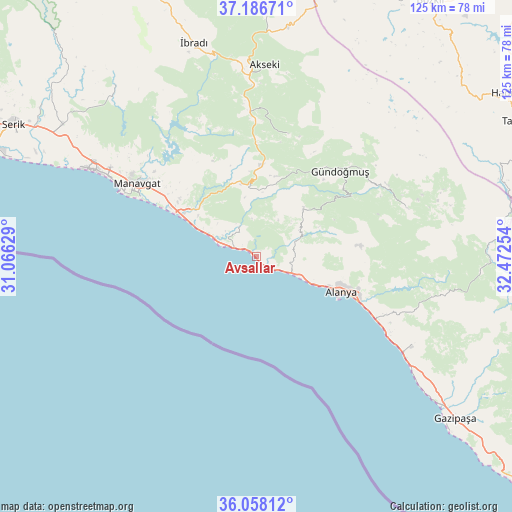
Avsallar GPS coordinates[2]
36° 37' 28.128" North, 31° 46' 9.876" East
| Map corner | latitude | longitude |
|---|---|---|
| Upper-left | 37.18671°, | 31.06629° |
| Center: | 36.62448°, | 31.76941° |
| Lower-right: | 36.05812°, | 32.47254° |
| Map W x H: | 125.5×125.5 km | = 78×78mi |
| max Lat: | 42.02683° ⇑96.1% North |
| Avsallar: | 36.62448° |
| min Lat: | ⇓3.9% South 35.9025° |
| min Long | Avsallar | max Long |
| 25.90902° | 31.76941° | 44.60099° |
| W 32.2%⇐ | ⇒67.8% E |
Elevation
Elevation of Avsallar is 30 m = 98 ft, and this is 687.4 m = 2255 ft below average elevation for this country.
| Max E: |
2682 m = 8799 ft | 91.8% |
| Avg. | 717.4 m = 2354 ft | |
| Avsallar | 30 m = 98 ft | |
Min E: |
0 m = 0 ft | 8.2% |
See also: Turkey elevation on elevation.city.
Geographical zone
Avsallar is located in North temperate zone (between Tropic of Cancer and the Arctic Circle). Distance of this Northern Tropic circle is 1466.3 km =911.1 mi to South.| Distance of | km | miles | from Avsallar |
|---|---|---|---|
| North Pole | 5934.8 | 3687.7 | to North |
| Arctic Circle | 3328.9 | 2068.5 | to North |
| Tropic Cancer | 1466.3 | 911.1 | to South |
| Equator | 4072.3 | 2530.4 | to South |


Nearby cities:
15 places around Avsallar: (largest is in red/bold)
• Alanya
22.4 km =13.9 mi,  113°
113°
• Demirtaş
43.8 km =27.2 mi,  120°
120°
• Eksere
29.4 km =18.3 mi,  44°
44°
• Evrenseki
43.9 km =27.3 mi,  302°
302°
• Geriş
37.7 km =23.4 mi,  355°
355°
• Güzelbağ
16.7 km =10.4 mi, 43°
• Güzelsu
31 km =19.3 mi,  14°
14°
• Köprülü
38.9 km =24.2 mi,  72°
72°
• Kızılağaç
24 km =14.9 mi, 299°
• Mahmutlar
32.1 km =19.9 mi, 116°
• Manavgat
34.2 km =21.3 mi, 301°
• Okurcalar
6.4 km =4 mi,  294°
294°
• Payallar
7.7 km =4.8 mi, 109°
• Side
37.4 km =23.2 mi, 294°
• Türkler
5.2 km =3.2 mi, 118°
Sources, notices
• [Note1] Compared only with cities in Turkey existing in our database
• [Src1] Map data: © OpenStreetMap contributors (CC-BY-SA)
• [Src2] Other city data from geonames.org with taken over terms of usage.
• [Src3] Geographical zone / Annual Mean Temperature by Robert A. Rohde @ Wikipedia
