Güzelsu geodata
Güzelsu (Antalya) is a seat of a third-order administrative division; located in Turkey in Europe/Istanbul (GMT+3) time zone. In our database, there are 1323 cities with bigger population. Compared to other cities in Turkey, 90.9% of cities are located further ↑North; 67.2% of cities are located further →East and 79.9% of cities have lower elevation than Güzelsu. Note1


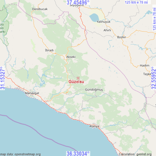
Güzelsu GPS coordinates[2]
36° 53' 40.992" North, 31° 51' 23.004" East
| Map corner | latitude | longitude |
|---|---|---|
| Upper-left | 37.45496°, | 31.15327° |
| Center: | 36.89472°, | 31.85639° |
| Lower-right: | 36.33034°, | 32.55952° |
| Map W x H: | 125×125 km | = 77.7×77.7mi |
| max Lat: | 42.02683° ⇑90.9% North |
| Güzelsu: | 36.89472° |
| min Lat: | ⇓9.1% South 35.9025° |
| min Long | Güzelsu | max Long |
| 25.90902° | 31.85639° | 44.60099° |
| W 32.8%⇐ | ⇒67.2% E |
Elevation
Elevation of Güzelsu is 1191 m = 3907 ft, and this is 473.6 m = 1554 ft above average elevation for this country.
| Max E: |
2682 m = 8799 ft | 20.1% |
| Güzelsu | 1191 m 3907 ft | |
| Avg. | 717.4 m = 2354 ft | |
Min E: |
0 m = 0 ft | 79.9% |
See also: Turkey elevation on elevation.city.
Geographical zone
Güzelsu is located in North temperate zone (between Tropic of Cancer and the Arctic Circle). Distance of this Northern Tropic circle is 1496.4 km =929.8 mi to South.| Distance of | km | miles | from Güzelsu |
|---|---|---|---|
| North Pole | 5904.8 | 3669.1 | to North |
| Arctic Circle | 3298.9 | 2049.8 | to North |
| Tropic Cancer | 1496.4 | 929.8 | to South |
| Equator | 4102.3 | 2549.1 | to South |


Nearby cities:
15 places around Güzelsu: (largest is in red/bold)
• Akseki
18.1 km =11.2 mi,  340°
340°
• Alanya
41.1 km =25.5 mi,  161°
161°
• Avsallar
31 km =19.3 mi,  194°
194°
• Cevizli
34.6 km =21.5 mi,  346°
346°
• Eksere
15.6 km =9.7 mi,  125°
125°
• Geriş
13.3 km =8.3 mi,  304°
304°
• Güzelbağ
18.3 km =11.4 mi,  168°
168°
• Köprülü
34.4 km =21.4 mi,  121°
121°
• Kızılağaç
33.9 km =21.1 mi,  237°
237°
• Manavgat
38.7 km =24 mi,  251°
251°
• Okurcalar
30.5 km =19 mi,  206°
206°
• Payallar
32.6 km =20.3 mi,  180°
180°
• Side
44 km =27.3 mi, 251°
• Türkler
32.7 km =20.3 mi, 185°
• İbradı
32.1 km =19.9 mi,  314°
314°
Sources, notices
• [Note1] Compared only with cities in Turkey existing in our database
• [Src1] Map data: © OpenStreetMap contributors (CC-BY-SA)
• [Src2] Other city data from geonames.org with taken over terms of usage.
• [Src3] Geographical zone / Annual Mean Temperature by Robert A. Rohde @ Wikipedia
