Köprülü geodata
Köprülü (Antalya) is a seat of a third-order administrative division; located in Turkey in Europe/Istanbul (GMT+3) time zone. In our database, there are 1323 cities with bigger population. Compared to other cities in Turkey, 94.6% of cities are located further ↑North; 65.7% of cities are located further →East and 57.6% of cities have lower elevation than Köprülü. Note1


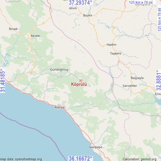
Köprülü GPS coordinates[2]
36° 43' 56.28" North, 32° 11' 5.892" East
| Map corner | latitude | longitude |
|---|---|---|
| Upper-left | 37.29374°, | 31.48185° |
| Center: | 36.7323°, | 32.18497° |
| Lower-right: | 36.16672°, | 32.8881° |
| Map W x H: | 125.3×125.3 km | = 77.9×77.9mi |
| max Lat: | 42.02683° ⇑94.6% North |
| Köprülü: | 36.7323° |
| min Lat: | ⇓5.4% South 35.9025° |
| min Long | Köprülü | max Long |
| 25.90902° | 32.18497° | 44.60099° |
| W 34.3%⇐ | ⇒65.7% E |
Elevation
Elevation of Köprülü is 837 m = 2746 ft, and this is 119.6 m = 392 ft above average elevation for this country.
| Max E: |
2682 m = 8799 ft | 42.4% |
| Köprülü | 837 m 2746 ft | |
| Avg. | 717.4 m = 2354 ft | |
Min E: |
0 m = 0 ft | 57.6% |
See also: Turkey elevation on elevation.city.
Geographical zone
Köprülü is located in North temperate zone (between Tropic of Cancer and the Arctic Circle). Distance of this Northern Tropic circle is 1478.3 km =918.6 mi to South.| Distance of | km | miles | from Köprülü |
|---|---|---|---|
| North Pole | 5922.8 | 3680.3 | to North |
| Arctic Circle | 3316.9 | 2061 | to North |
| Tropic Cancer | 1478.3 | 918.6 | to South |
| Equator | 4084.2 | 2537.8 | to South |


Nearby cities:
15 places around Köprülü: (largest is in red/bold)
• Alanya
26.7 km =16.6 mi,  218°
218°
• Avsallar
38.9 km =24.2 mi,  252°
252°
• Başyayla
44.2 km =27.5 mi,  86°
86°
• Demirtaş
34.1 km =21.2 mi,  178°
178°
• Eksere
18.8 km =11.7 mi,  298°
298°
• Göktepe
40.8 km =25.4 mi,  106°
106°
• Güzelbağ
25.5 km =15.8 mi,  270°
270°
• Güzelsu
34.4 km =21.4 mi, 301°
• Hadim
37.3 km =23.2 mi,  40°
40°
• Mahmutlar
27.7 km =17.2 mi,  197°
197°
• Okurcalar
43.9 km =27.3 mi,  257°
257°
• Payallar
33.2 km =20.6 mi,  244°
244°
• Sarıveliler
38.3 km =23.8 mi,  95°
95°
• Taşkent
34.6 km =21.5 mi,  51°
51°
• Türkler
35.6 km =22.1 mi, 245°
Sources, notices
• [Note1] Compared only with cities in Turkey existing in our database
• [Src1] Map data: © OpenStreetMap contributors (CC-BY-SA)
• [Src2] Other city data from geonames.org with taken over terms of usage.
• [Src3] Geographical zone / Annual Mean Temperature by Robert A. Rohde @ Wikipedia
