Türkler geodata
Türkler (Antalya) is a populated place; located in Turkey in Europe/Istanbul (GMT+3) time zone. With population of 7,240 people, there are 608 cities with bigger population in this country. Compared to other cities in Turkey, 96.3% of cities are located further ↑North; 67.4% of cities are located further →East and 99.1% of cities have higher elevation than Türkler. Note1


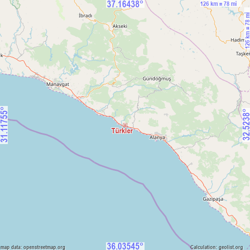
Türkler GPS coordinates[2]
36° 36' 7.128" North, 31° 49' 14.412" East
| Map corner | latitude | longitude |
|---|---|---|
| Upper-left | 37.16438°, | 31.11755° |
| Center: | 36.60198°, | 31.82067° |
| Lower-right: | 36.03545°, | 32.5238° |
| Map W x H: | 125.5×125.5 km | = 78×78mi |
| max Lat: | 42.02683° ⇑96.3% North |
| Türkler: | 36.60198° |
| min Lat: | ⇓3.7% South 35.9025° |
| min Long | Türkler | max Long |
| 25.90902° | 31.82067° | 44.60099° |
| W 32.6%⇐ | ⇒67.4% E |
Elevation
Elevation of Türkler is 6 m = 20 ft, and this is 711.4 m = 2334 ft below average elevation for this country.
| Max E: |
2682 m = 8799 ft | 99.1% |
| Avg. | 717.4 m = 2354 ft | |
| Türkler | 6 m = 20 ft | |
Min E: |
0 m = 0 ft | 0.9% |
See also: Turkey elevation on elevation.city.
Geographical zone
Türkler is located in North temperate zone (between Tropic of Cancer and the Arctic Circle). Distance of this Northern Tropic circle is 1463.8 km =909.6 mi to South.| Distance of | km | miles | from Türkler |
|---|---|---|---|
| North Pole | 5937.3 | 3689.3 | to North |
| Arctic Circle | 3331.4 | 2070 | to North |
| Tropic Cancer | 1463.8 | 909.6 | to South |
| Equator | 4069.8 | 2528.9 | to South |


Nearby cities:
15 places around Türkler: (largest is in red/bold)
• Alanya
17.3 km =10.7 mi,  112°
112°
• Avsallar
5.2 km =3.2 mi,  298°
298°
• Demirtaş
38.6 km =24 mi,  120°
120°
• Eksere
28.4 km =17.6 mi,  34°
34°
• Evrenseki
49.1 km =30.5 mi, 302°
• Geriş
40.8 km =25.4 mi,  348°
348°
• Güzelbağ
16.2 km =10.1 mi, 25°
• Güzelsu
32.7 km =20.3 mi,  5°
5°
• Köprülü
35.6 km =22.1 mi,  65°
65°
• Kızılağaç
29.2 km =18.1 mi, 299°
• Mahmutlar
26.9 km =16.7 mi, 116°
• Manavgat
39.4 km =24.5 mi, 301°
• Okurcalar
11.6 km =7.2 mi, 296°
• Payallar
2.7 km =1.7 mi,  90°
90°
• Side
42.6 km =26.5 mi, 295°
Sources, notices
• [Note1] Compared only with cities in Turkey existing in our database
• [Src1] Map data: © OpenStreetMap contributors (CC-BY-SA)
• [Src2] Other city data from geonames.org with taken over terms of usage.
• [Src3] Geographical zone / Annual Mean Temperature by Robert A. Rohde @ Wikipedia
