Oğuz geodata
Oğuz (Batman) is a seat of a third-order administrative division; located in Turkey in Europe/Istanbul (GMT+3) time zone. In our database, there are 1323 cities with bigger population. Compared to other cities in Turkey, 68.1% of cities are located further ↑North; 85.1% of cities are located further ←West and 59.1% of cities have lower elevation than Oğuz. Note1


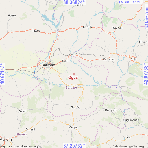
Oğuz GPS coordinates[2]
37° 48' 53.532" North, 41° 22' 27.3" East
| Map corner | latitude | longitude |
|---|---|---|
| Upper-left | 38.36824°, | 40.67113° |
| Center: | 37.81487°, | 41.37425° |
| Lower-right: | 37.25732°, | 42.07738° |
| Map W x H: | 123.5×123.5 km | = 76.7×76.7mi |
| max Lat: | 42.02683° ⇑68.1% North |
| Oğuz: | 37.81487° |
| min Lat: | ⇓31.9% South 35.9025° |
| min Long | Oğuz | max Long |
| 25.90902° | 41.37425° | 44.60099° |
| W 85.1%⇐ | ⇒14.9% E |
Elevation
Elevation of Oğuz is 866 m = 2841 ft, and this is 148.6 m = 488 ft above average elevation for this country.
| Max E: |
2682 m = 8799 ft | 40.9% |
| Oğuz | 866 m 2841 ft | |
| Avg. | 717.4 m = 2354 ft | |
Min E: |
0 m = 0 ft | 59.1% |
See also: Turkey elevation on elevation.city.
Geographical zone
Oğuz is located in North temperate zone (between Tropic of Cancer and the Arctic Circle). Distance of this Northern Tropic circle is 1598.7 km =993.4 mi to South.| Distance of | km | miles | from Oğuz |
|---|---|---|---|
| North Pole | 5802.4 | 3605.4 | to North |
| Arctic Circle | 3196.6 | 1986.3 | to North |
| Tropic Cancer | 1598.7 | 993.4 | to South |
| Equator | 4204.6 | 2612.6 | to South |


Nearby cities:
15 places around Oğuz: (largest is in red/bold)
• Akça
17.4 km =10.8 mi,  284°
284°
• Asmadere
10.6 km =6.6 mi,  357°
357°
• Aviski
17.1 km =10.6 mi,  347°
347°
• Beşiri
13.6 km =8.5 mi,  325°
325°
• Binatlı
14.3 km =8.9 mi, 284°
• Danalı
12.7 km =7.9 mi,  306°
306°
• Gökdoğan
15.6 km =9.7 mi,  9°
9°
• Hasankeyf
12.4 km =7.7 mi,  167°
167°
• Karaköy
15 km =9.3 mi, 167°
• Kesmeköprü
11.4 km =7.1 mi,  162°
162°
• Kösetarla
17.5 km =10.9 mi,  298°
298°
• Taliban
18.8 km =11.7 mi, 10°
• Yenipınar
7.1 km =4.4 mi, 295°
• Yontukyazı
8.6 km =5.3 mi, 332°
• Çevrimova
9.3 km =5.8 mi,  287°
287°
Sources, notices
• [Note1] Compared only with cities in Turkey existing in our database
• [Src1] Map data: © OpenStreetMap contributors (CC-BY-SA)
• [Src2] Other city data from geonames.org with taken over terms of usage.
• [Src3] Geographical zone / Annual Mean Temperature by Robert A. Rohde @ Wikipedia
