Kastal geodata
Kastal (Hatay) is a populated place; located in Turkey in Europe/Istanbul (GMT+3) time zone. With population of 5,637 people, there are 675 cities with bigger population in this country. Compared to other cities in Turkey, 98.1% of cities are located further ↑North; 52.9% of cities are located further ←West and 82.2% of cities have higher elevation than Kastal. Note1


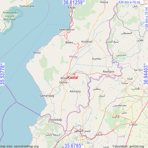
Kastal GPS coordinates[2]
36° 14' 51.36" North, 36° 14' 27.24" East
| Map corner | latitude | longitude |
|---|---|---|
| Upper-left | 36.81259°, | 35.53778° |
| Center: | 36.2476°, | 36.2409° |
| Lower-right: | 35.6785°, | 36.94403° |
| Map W x H: | 126.1×126.1 km | = 78.4×78.4mi |
| max Lat: | 42.02683° ⇑98.1% North |
| Kastal: | 36.2476° |
| min Lat: | ⇓1.9% South 35.9025° |
| min Long | Kastal | max Long |
| 25.90902° | 36.2409° | 44.60099° |
| W 52.9%⇐ | ⇒47.1% E |
Elevation
Elevation of Kastal is 94 m = 308 ft, and this is 623.4 m = 2045 ft below average elevation for this country.
| Max E: |
2682 m = 8799 ft | 82.2% |
| Avg. | 717.4 m = 2354 ft | |
| Kastal | 94 m = 308 ft | |
Min E: |
0 m = 0 ft | 17.8% |
See also: Turkey elevation on elevation.city.
Geographical zone
Kastal is located in North temperate zone (between Tropic of Cancer and the Arctic Circle). Distance of this Northern Tropic circle is 1424.4 km =885.1 mi to South.| Distance of | km | miles | from Kastal |
|---|---|---|---|
| North Pole | 5976.7 | 3713.7 | to North |
| Arctic Circle | 3370.8 | 2094.5 | to North |
| Tropic Cancer | 1424.4 | 885.1 | to South |
| Equator | 4030.4 | 2504.4 | to South |


Nearby cities:
15 places around Kastal: (largest is in red/bold)
• Anayazı
9.3 km =5.8 mi,  331°
331°
• Antakya
8.8 km =5.5 mi,  238°
238°
• Atayurdu
8.2 km =5.1 mi,  154°
154°
• Açıkdere
3.6 km =2.2 mi, 151°
• Aşağıokçular
11.9 km =7.4 mi,  229°
229°
• Boynuyoğun
12.6 km =7.8 mi,  133°
133°
• Büyük Dalyan
5.3 km =3.3 mi, 327°
• Doğanköy
11.9 km =7.4 mi,  262°
262°
• Dursunlu
11.6 km =7.2 mi,  219°
219°
• Günyazı
11.2 km =7 mi, 261°
• Hıdırbey
11.1 km =6.9 mi,  246°
246°
• Kuzeytepe
8.1 km =5 mi,  283°
283°
• Mansurlu
3.1 km =1.9 mi,  196°
196°
• Tepehan
10 km =6.2 mi,  186°
186°
• Yeşilova
2.7 km =1.7 mi,  26°
26°
Sources, notices
• [Note1] Compared only with cities in Turkey existing in our database
• [Src1] Map data: © OpenStreetMap contributors (CC-BY-SA)
• [Src2] Other city data from geonames.org with taken over terms of usage.
• [Src3] Geographical zone / Annual Mean Temperature by Robert A. Rohde @ Wikipedia
