Geçitli geodata
Geçitli (Hakkâri) is a seat of a third-order administrative division; located in Turkey in Europe/Istanbul (GMT+3) time zone. In our database, there are 1323 cities with bigger population. Compared to other cities in Turkey, 72.4% of cities are located further ↑North; 98.8% of cities are located further ←West and 96.7% of cities have lower elevation than Geçitli. Note1


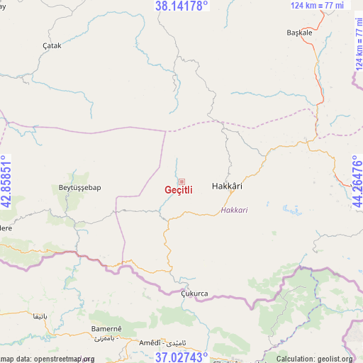
Geçitli GPS coordinates[2]
37° 35' 12.084" North, 43° 33' 41.868" East
| Map corner | latitude | longitude |
|---|---|---|
| Upper-left | 38.14178°, | 42.85851° |
| Center: | 37.58669°, | 43.56163° |
| Lower-right: | 37.02743°, | 44.26476° |
| Map W x H: | 123.9×123.9 km | = 77×77mi |
| max Lat: | 42.02683° ⇑72.4% North |
| Geçitli: | 37.58669° |
| min Lat: | ⇓27.6% South 35.9025° |
| min Long | Geçitli | max Long |
| 25.90902° | 43.56163° | 44.60099° |
| W 98.8%⇐ | ⇒1.2% E |
Elevation
Elevation of Geçitli is 1778 m = 5833 ft, and this is 1060.6 m = 3480 ft above average elevation for this country.
| Max E: |
2682 m = 8799 ft | 3.3% |
| Geçitli | 1778 m 5833 ft | |
| Avg. | 717.4 m = 2354 ft | |
Min E: |
0 m = 0 ft | 96.7% |
See also: Turkey elevation on elevation.city.
Geographical zone
Geçitli is located in North temperate zone (between Tropic of Cancer and the Arctic Circle). Distance of this Northern Tropic circle is 1573.3 km =977.6 mi to South.| Distance of | km | miles | from Geçitli |
|---|---|---|---|
| North Pole | 5827.8 | 3621.2 | to North |
| Arctic Circle | 3221.9 | 2002 | to North |
| Tropic Cancer | 1573.3 | 977.6 | to South |
| Equator | 4179.2 | 2596.8 | to South |


Nearby cities:
15 places around Geçitli: (largest is in red/bold)
• Andaç
36.8 km =22.9 mi,  225°
225°
• Ashuta
33.6 km =20.9 mi,  209°
209°
• Aşağıdere
39.8 km =24.7 mi,  258°
258°
• Başaran
40 km =24.9 mi,  252°
252°
• Beytüşşebap
35 km =21.7 mi,  265°
265°
• Buğdaylı
31.2 km =19.4 mi,  290°
290°
• Hakkâri
15.8 km =9.8 mi,  94°
94°
• Karchane
37.6 km =23.4 mi,  275°
275°
• Karsani
32.5 km =20.2 mi,  196°
196°
• Kelitan
21.9 km =13.6 mi, 204°
• Mezraa
33.9 km =21.1 mi, 284°
• Ortaköy
37.8 km =23.5 mi,  220°
220°
• Oymakaya
34.3 km =21.3 mi,  238°
238°
• Yalınca
30.2 km =18.8 mi,  353°
353°
• Çukurca
37.9 km =23.5 mi,  173°
173°
Sources, notices
• [Note1] Compared only with cities in Turkey existing in our database
• [Src1] Map data: © OpenStreetMap contributors (CC-BY-SA)
• [Src2] Other city data from geonames.org with taken over terms of usage.
• [Src3] Geographical zone / Annual Mean Temperature by Robert A. Rohde @ Wikipedia
