Hakkâri geodata
Hakkâri is a seat of a first-order administrative division; located in Turkey in Europe/Istanbul (GMT+3) time zone. With population of 77,699 people, there are 115 cities with bigger population in this country. Compared to other cities in Turkey, 72.8% of cities are located further ↑North; 99.2% of cities are located further ←West and 95.4% of cities have lower elevation than Hakkâri. Note1


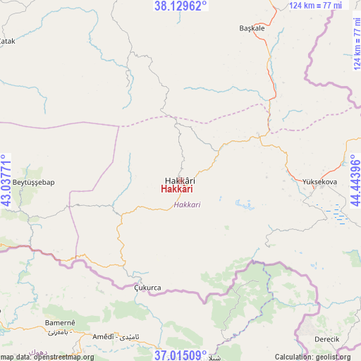
Hakkâri GPS coordinates[2]
37° 34' 27.984" North, 43° 44' 26.988" East
| Map corner | latitude | longitude |
|---|---|---|
| Upper-left | 38.12962°, | 43.03771° |
| Center: | 37.57444°, | 43.74083° |
| Lower-right: | 37.01509°, | 44.44396° |
| Map W x H: | 123.9×123.9 km | = 77×77mi |
| max Lat: | 42.02683° ⇑72.8% North |
| Hakkâri: | 37.57444° |
| min Lat: | ⇓27.2% South 35.9025° |
| min Long | Hakkâri | max Long |
| 25.90902° | 43.74083° | 44.60099° |
| W 99.2%⇐ | ⇒0.8% E |
Elevation
Elevation of Hakkâri is 1697 m = 5568 ft, and this is 979.6 m = 3214 ft above average elevation for this country.
| Max E: |
2682 m = 8799 ft | 4.6% |
| Hakkâri | 1697 m 5568 ft | |
| Avg. | 717.4 m = 2354 ft | |
Min E: |
0 m = 0 ft | 95.4% |
See also: Hakkâri elevation on elevation.city.
Geographical zone
Hakkâri is located in North temperate zone (between Tropic of Cancer and the Arctic Circle). Distance of this Northern Tropic circle is 1572 km =976.8 mi to South.| Distance of | km | miles | from Hakkâri |
|---|---|---|---|
| North Pole | 5829.2 | 3622.1 | to North |
| Arctic Circle | 3223.3 | 2002.9 | to North |
| Tropic Cancer | 1572 | 976.8 | to South |
| Equator | 4177.9 | 2596 | to South |


Nearby cities:
15 places around Hakkâri: (largest is in red/bold)
• Andaç
48.6 km =30.2 mi,  239°
239°
• Ashuta
42.7 km =26.5 mi,  229°
229°
• Beytüşşebap
50.7 km =31.5 mi,  268°
268°
• Buğdaylı
46.6 km =29 mi,  285°
285°
• Dağlıca
38.2 km =23.7 mi,  127°
127°
• Geçitli
15.8 km =9.8 mi, 274°
• Hazekyan
30.4 km =18.9 mi,  58°
58°
• Karsani
39 km =24.2 mi,  220°
220°
• Kelitan
31.1 km =19.3 mi, 233°
• Mezraa
49.6 km =30.8 mi,  281°
281°
• Ortaköy
48.8 km =30.3 mi, 235°
• Oymakaya
48 km =29.8 mi,  249°
249°
• Yalınca
36.8 km =22.9 mi,  328°
328°
• Yüksekova
48.1 km =29.9 mi,  90°
90°
• Çukurca
38 km =23.6 mi,  197°
197°
Sources, notices
• [Note1] Compared only with cities in Turkey existing in our database
• [Src1] Map data: © OpenStreetMap contributors (CC-BY-SA)
• [Src2] Other city data from geonames.org with taken over terms of usage.
• [Src3] Geographical zone / Annual Mean Temperature by Robert A. Rohde @ Wikipedia
