Yalova geodata
Yalova is a seat of a first-order administrative division; located in Turkey in Europe/Istanbul (GMT+3) time zone. With population of 71,289 people, there are 130 cities with bigger population in this country. Compared to other cities in Turkey, 80.1% of cities are located further ↓South; 81.2% of cities are located further →East and 98.3% of cities have higher elevation than Yalova. Note1


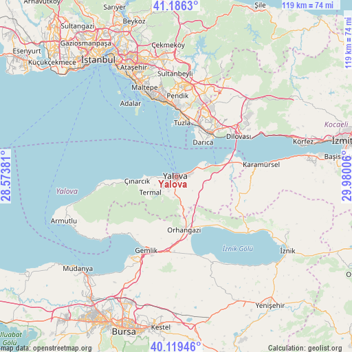
Yalova GPS coordinates[2]
40° 39' 18.036" North, 29° 16' 36.948" East
| Map corner | latitude | longitude |
|---|---|---|
| Upper-left | 41.1863°, | 28.57381° |
| Center: | 40.65501°, | 29.27693° |
| Lower-right: | 40.11946°, | 29.98006° |
| Map W x H: | 118.6×118.6 km | = 73.7×73.7mi |
| max Lat: | 42.02683° ⇑19.9% North |
| Yalova: | 40.65501° |
| min Lat: | ⇓80.1% South 35.9025° |
| min Long | Yalova | max Long |
| 25.90902° | 29.27693° | 44.60099° |
| W 18.8%⇐ | ⇒81.2% E |
Elevation
Elevation of Yalova is 9 m = 30 ft, and this is 708.4 m = 2324 ft below average elevation for this country.
| Max E: |
2682 m = 8799 ft | 98.3% |
| Avg. | 717.4 m = 2354 ft | |
| Yalova | 9 m = 30 ft | |
Min E: |
0 m = 0 ft | 1.7% |
See also: Yalova elevation on elevation.city.
Geographical zone
Yalova is located in North temperate zone (between Tropic of Cancer and the Arctic Circle). Distance of this Northern Tropic circle is 1914.5 km =1189.6 mi to South.| Distance of | km | miles | from Yalova |
|---|---|---|---|
| North Pole | 5486.6 | 3409.2 | to North |
| Arctic Circle | 2880.8 | 1790 | to North |
| Tropic Cancer | 1914.5 | 1189.6 | to South |
| Equator | 4520.4 | 2808.8 | to South |


Nearby cities:
15 places around Yalova: (largest is in red/bold)
• Altınova
20.1 km =12.5 mi,  77°
77°
• Darıca
17 km =10.6 mi,  35°
35°
• Gebze
20.9 km =13 mi, 38°
• Kadıköy
5.8 km =3.6 mi,  228°
228°
• Kocadere
21 km =13 mi,  262°
262°
• Koruköy
9.6 km =6 mi,  269°
269°
• Kılıç
10.2 km =6.3 mi,  103°
103°
• Orhangazi
18.6 km =11.6 mi,  171°
171°
• Soğuksu
19.6 km =12.2 mi, 84°
• Taşköprü
9.8 km =6.1 mi, 77°
• Termal
10.2 km =6.3 mi,  238°
238°
• Yeniköy
14.8 km =9.2 mi,  153°
153°
• Çiftlikköy
4 km =2.5 mi, 81°
• Çukurköy
12.5 km =7.8 mi,  116°
116°
• Çınarcık
12.9 km =8 mi, 265°
Sources, notices
• [Note1] Compared only with cities in Turkey existing in our database
• [Src1] Map data: © OpenStreetMap contributors (CC-BY-SA)
• [Src2] Other city data from geonames.org with taken over terms of usage.
• [Src3] Geographical zone / Annual Mean Temperature by Robert A. Rohde @ Wikipedia
