Kocadere geodata
Kocadere (Yalova) is a populated place; located in Turkey in Europe/Istanbul (GMT+3) time zone. With population of 1,137 people, there are 1060 cities with bigger population in this country. Compared to other cities in Turkey, 79.5% of cities are located further ↓South; 83.8% of cities are located further →East and 92% of cities have higher elevation than Kocadere. Note1


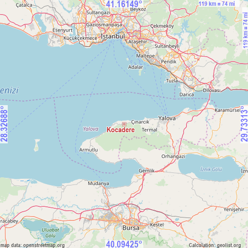
Kocadere GPS coordinates[2]
40° 37' 48" North, 29° 1' 48" East
| Map corner | latitude | longitude |
|---|---|---|
| Upper-left | 41.16149°, | 28.32688° |
| Center: | 40.63°, | 29.03° |
| Lower-right: | 40.09425°, | 29.73313° |
| Map W x H: | 118.7×118.7 km | = 73.8×73.8mi |
| max Lat: | 42.02683° ⇑20.5% North |
| Kocadere: | 40.63° |
| min Lat: | ⇓79.5% South 35.9025° |
| min Long | Kocadere | max Long |
| 25.90902° | 29.03° | 44.60099° |
| W 16.2%⇐ | ⇒83.8% E |
Elevation
Elevation of Kocadere is 29 m = 95 ft, and this is 688.4 m = 2259 ft below average elevation for this country.
| Max E: |
2682 m = 8799 ft | 92% |
| Avg. | 717.4 m = 2354 ft | |
| Kocadere | 29 m = 95 ft | |
Min E: |
0 m = 0 ft | 8% |
See also: Turkey elevation on elevation.city.
Geographical zone
Kocadere is located in North temperate zone (between Tropic of Cancer and the Arctic Circle). Distance of this Northern Tropic circle is 1911.7 km =1187.9 mi to South.| Distance of | km | miles | from Kocadere |
|---|---|---|---|
| North Pole | 5489.4 | 3411 | to North |
| Arctic Circle | 2883.5 | 1791.7 | to North |
| Tropic Cancer | 1911.7 | 1187.9 | to South |
| Equator | 4517.6 | 2807.1 | to South |


Nearby cities:
15 places around Kocadere: (largest is in red/bold)
• Adalan
27.8 km =17.3 mi,  10°
10°
• Adalar
27.8 km =17.3 mi,  18°
18°
• Armutlu
21 km =13 mi,  234°
234°
• Gemlik
24.7 km =15.3 mi,  153°
153°
• Kadıköy
16.5 km =10.3 mi,  93°
93°
• Karacaali
17.1 km =10.6 mi,  169°
169°
• Koruköy
11.5 km =7.1 mi,  76°
76°
• Küçükkumla
18.7 km =11.6 mi,  161°
161°
• Orhangazi
28.3 km =17.6 mi,  123°
123°
• Termal
12.4 km =7.7 mi,  101°
101°
• Umurbey
27.2 km =16.9 mi, 151°
• Yalova
21 km =13 mi, 82°
• Yeniköy
29.3 km =18.2 mi,  110°
110°
• Çiftlikköy
25 km =15.5 mi, 82°
• Çınarcık
8.2 km =5.1 mi, 77°
Sources, notices
• [Note1] Compared only with cities in Turkey existing in our database
• [Src1] Map data: © OpenStreetMap contributors (CC-BY-SA)
• [Src2] Other city data from geonames.org with taken over terms of usage.
• [Src3] Geographical zone / Annual Mean Temperature by Robert A. Rohde @ Wikipedia
