Çınarcık geodata
Çınarcık (Yalova) is a seat of a second-order administrative division; located in Turkey in Europe/Istanbul (GMT+3) time zone. With population of 7,629 people, there are 589 cities with bigger population in this country. Compared to other cities in Turkey, 79.9% of cities are located further ↓South; 82.7% of cities are located further →East and 93.4% of cities have higher elevation than Çınarcık. Note1


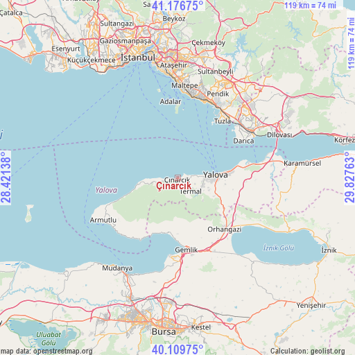
Çınarcık GPS coordinates[2]
40° 38' 43.368" North, 29° 7' 28.2" East
| Map corner | latitude | longitude |
|---|---|---|
| Upper-left | 41.17675°, | 28.42138° |
| Center: | 40.64538°, | 29.1245° |
| Lower-right: | 40.10975°, | 29.82763° |
| Map W x H: | 118.6×118.6 km | = 73.7×73.7mi |
| max Lat: | 42.02683° ⇑20.1% North |
| Çınarcık: | 40.64538° |
| min Lat: | ⇓79.9% South 35.9025° |
| min Long | Çınarcık | max Long |
| 25.90902° | 29.1245° | 44.60099° |
| W 17.3%⇐ | ⇒82.7% E |
Elevation
Elevation of Çınarcık is 23 m = 75 ft, and this is 694.4 m = 2278 ft below average elevation for this country.
| Max E: |
2682 m = 8799 ft | 93.4% |
| Avg. | 717.4 m = 2354 ft | |
| Çınarcık | 23 m = 75 ft | |
Min E: |
0 m = 0 ft | 6.6% |
See also: Turkey elevation on elevation.city.
Geographical zone
Çınarcık is located in North temperate zone (between Tropic of Cancer and the Arctic Circle). Distance of this Northern Tropic circle is 1913.4 km =1188.9 mi to South.| Distance of | km | miles | from Çınarcık |
|---|---|---|---|
| North Pole | 5487.7 | 3409.9 | to North |
| Arctic Circle | 2881.8 | 1790.7 | to North |
| Tropic Cancer | 1913.4 | 1188.9 | to South |
| Equator | 4519.3 | 2808.2 | to South |


Nearby cities:
15 places around Çınarcık: (largest is in red/bold)
• Adalar
24.7 km =15.3 mi,  1°
1°
• Gemlik
24 km =14.9 mi,  172°
172°
• Kadıköy
9 km =5.6 mi,  108°
108°
• Karacaali
19.1 km =11.9 mi,  194°
194°
• Kocadere
8.2 km =5.1 mi,  257°
257°
• Koruköy
3.4 km =2.1 mi,  72°
72°
• Küçükkumla
19.5 km =12.1 mi, 185°
• Kılıç
22.8 km =14.2 mi,  93°
93°
• Orhangazi
23.3 km =14.5 mi,  138°
138°
• Taşköprü
22.7 km =14.1 mi,  82°
82°
• Termal
5.9 km =3.7 mi, 135°
• Yalova
12.9 km =8 mi, 85°
• Yeniköy
22.9 km =14.2 mi,  122°
122°
• Çiftlikköy
16.9 km =10.5 mi, 84°
• Çukurköy
24.5 km =15.2 mi,  100°
100°
Sources, notices
• [Note1] Compared only with cities in Turkey existing in our database
• [Src1] Map data: © OpenStreetMap contributors (CC-BY-SA)
• [Src2] Other city data from geonames.org with taken over terms of usage.
• [Src3] Geographical zone / Annual Mean Temperature by Robert A. Rohde @ Wikipedia
