Termal geodata
Termal (Yalova) is a seat of a second-order administrative division; located in Turkey in Europe/Istanbul (GMT+3) time zone. In our database, there are 1323 cities with bigger population. Compared to other cities in Turkey, 79.1% of cities are located further ↓South; 82.1% of cities are located further →East and 79.8% of cities have higher elevation than Termal. Note1


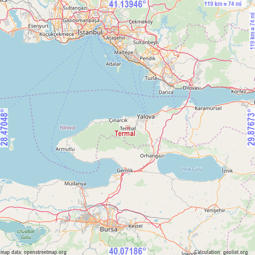
Termal GPS coordinates[2]
40° 36' 28.044" North, 29° 10' 24.96" East
| Map corner | latitude | longitude |
|---|---|---|
| Upper-left | 41.13946°, | 28.47048° |
| Center: | 40.60779°, | 29.1736° |
| Lower-right: | 40.07186°, | 29.87673° |
| Map W x H: | 118.7×118.7 km | = 73.8×73.8mi |
| max Lat: | 42.02683° ⇑20.9% North |
| Termal: | 40.60779° |
| min Lat: | ⇓79.1% South 35.9025° |
| min Long | Termal | max Long |
| 25.90902° | 29.1736° | 44.60099° |
| W 17.9%⇐ | ⇒82.1% E |
Elevation
Elevation of Termal is 118 m = 387 ft, and this is 599.4 m = 1967 ft below average elevation for this country.
| Max E: |
2682 m = 8799 ft | 79.8% |
| Avg. | 717.4 m = 2354 ft | |
| Termal | 118 m = 387 ft | |
Min E: |
0 m = 0 ft | 20.2% |
See also: Turkey elevation on elevation.city.
Geographical zone
Termal is located in North temperate zone (between Tropic of Cancer and the Arctic Circle). Distance of this Northern Tropic circle is 1909.2 km =1186.3 mi to South.| Distance of | km | miles | from Termal |
|---|---|---|---|
| North Pole | 5491.9 | 3412.5 | to North |
| Arctic Circle | 2886 | 1793.3 | to North |
| Tropic Cancer | 1909.2 | 1186.3 | to South |
| Equator | 4515.2 | 2805.6 | to South |


Nearby cities:
15 places around Termal: (largest is in red/bold)
• Gemlik
19.7 km =12.2 mi,  183°
183°
• Kadıköy
4.6 km =2.9 mi,  72°
72°
• Karacaali
16.8 km =10.4 mi,  211°
211°
• Kocadere
12.4 km =7.7 mi,  281°
281°
• Koruköy
5.3 km =3.3 mi,  350°
350°
• Küçükkumla
16.4 km =10.2 mi,  201°
201°
• Kılıç
18.9 km =11.7 mi,  81°
81°
• Orhangazi
17.5 km =10.9 mi,  139°
139°
• Taşköprü
19.8 km =12.3 mi, 68°
• Umurbey
21.5 km =13.4 mi, 177°
• Yalova
10.2 km =6.3 mi,  58°
58°
• Yeniköy
17.2 km =10.7 mi,  117°
117°
• Çiftlikköy
13.9 km =8.6 mi, 65°
• Çukurköy
20 km =12.4 mi,  91°
91°
• Çınarcık
5.9 km =3.7 mi,  315°
315°
Sources, notices
• [Note1] Compared only with cities in Turkey existing in our database
• [Src1] Map data: © OpenStreetMap contributors (CC-BY-SA)
• [Src2] Other city data from geonames.org with taken over terms of usage.
• [Src3] Geographical zone / Annual Mean Temperature by Robert A. Rohde @ Wikipedia
