Orhangazi geodata
Orhangazi (Bursa) is a seat of a second-order administrative division; located in Turkey in Europe/Istanbul (GMT+3) time zone. With population of 51,792 people, there are 167 cities with bigger population in this country. Compared to other cities in Turkey, 77.5% of cities are located further ↓South; 81% of cities are located further →East and 79.4% of cities have higher elevation than Orhangazi. Note1


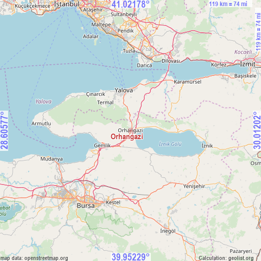
Orhangazi GPS coordinates[2]
40° 29' 21.012" North, 29° 18' 32.004" East
| Map corner | latitude | longitude |
|---|---|---|
| Upper-left | 41.02178°, | 28.60577° |
| Center: | 40.48917°, | 29.30889° |
| Lower-right: | 39.95229°, | 30.01202° |
| Map W x H: | 118.9×118.9 km | = 73.9×73.9mi |
| max Lat: | 42.02683° ⇑22.5% North |
| Orhangazi: | 40.48917° |
| min Lat: | ⇓77.5% South 35.9025° |
| min Long | Orhangazi | max Long |
| 25.90902° | 29.30889° | 44.60099° |
| W 19%⇐ | ⇒81% E |
Elevation
Elevation of Orhangazi is 120 m = 394 ft, and this is 597.4 m = 1960 ft below average elevation for this country.
| Max E: |
2682 m = 8799 ft | 79.4% |
| Avg. | 717.4 m = 2354 ft | |
| Orhangazi | 120 m = 394 ft | |
Min E: |
0 m = 0 ft | 20.6% |
See also: Orhangazi elevation on elevation.city.
Geographical zone
Orhangazi is located in North temperate zone (between Tropic of Cancer and the Arctic Circle). Distance of this Northern Tropic circle is 1896.1 km =1178.2 mi to South.| Distance of | km | miles | from Orhangazi |
|---|---|---|---|
| North Pole | 5505.1 | 3420.7 | to North |
| Arctic Circle | 2899.2 | 1801.5 | to North |
| Tropic Cancer | 1896.1 | 1178.2 | to South |
| Equator | 4502 | 2797.4 | to South |


Nearby cities:
15 places around Orhangazi: (largest is in red/bold)
• Gemlik
14.2 km =8.8 mi,  242°
242°
• Kadıköy
16.2 km =10.1 mi,  334°
334°
• Karacaali
20.4 km =12.7 mi,  266°
266°
• Küçükkumla
17.7 km =11 mi,  263°
263°
• Kılıç
17.6 km =10.9 mi,  24°
24°
• Narlıca
18.6 km =11.6 mi,  128°
128°
• Seçköy
20.7 km =12.9 mi,  207°
207°
• Sölöz
13.8 km =8.6 mi,  139°
139°
• Termal
17.5 km =10.9 mi,  319°
319°
• Umurbey
13.5 km =8.4 mi,  232°
232°
• Yalova
18.6 km =11.6 mi,  351°
351°
• Yeniköy
6.4 km =4 mi,  36°
36°
• Çakırlı
12.5 km =7.8 mi,  75°
75°
• Çiftlikköy
19.1 km =11.9 mi,  3°
3°
• Çukurköy
15.4 km =9.6 mi,  33°
33°
Sources, notices
• [Note1] Compared only with cities in Turkey existing in our database
• [Src1] Map data: © OpenStreetMap contributors (CC-BY-SA)
• [Src2] Other city data from geonames.org with taken over terms of usage.
• [Src3] Geographical zone / Annual Mean Temperature by Robert A. Rohde @ Wikipedia
