Tacir geodata
Tacir (Bursa) is a populated place; located in Turkey in Europe/Istanbul (GMT+3) time zone. With population of 1,915 people, there are 967 cities with bigger population in this country. Compared to other cities in Turkey, 78% of cities are located further ↓South; 77.6% of cities are located further →East and 63.9% of cities have higher elevation than Tacir. Note1


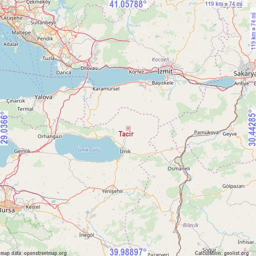
Tacir GPS coordinates[2]
40° 31' 32.016" North, 29° 44' 22.992" East
| Map corner | latitude | longitude |
|---|---|---|
| Upper-left | 41.05788°, | 29.0366° |
| Center: | 40.52556°, | 29.73972° |
| Lower-right: | 39.98897°, | 30.44285° |
| Map W x H: | 118.9×118.9 km | = 73.9×73.9mi |
| max Lat: | 42.02683° ⇑22% North |
| Tacir: | 40.52556° |
| min Lat: | ⇓78% South 35.9025° |
| min Long | Tacir | max Long |
| 25.90902° | 29.73972° | 44.60099° |
| W 22.4%⇐ | ⇒77.6% E |
Elevation
Elevation of Tacir is 435 m = 1427 ft, and this is 282.4 m = 927 ft below average elevation for this country.
| Max E: |
2682 m = 8799 ft | 63.9% |
| Avg. | 717.4 m = 2354 ft | |
| Tacir | 435 m = 1427 ft | |
Min E: |
0 m = 0 ft | 36.1% |
See also: Turkey elevation on elevation.city.
Geographical zone
Tacir is located in North temperate zone (between Tropic of Cancer and the Arctic Circle). Distance of this Northern Tropic circle is 1900.1 km =1180.7 mi to South.| Distance of | km | miles | from Tacir |
|---|---|---|---|
| North Pole | 5501 | 3418.2 | to North |
| Arctic Circle | 2895.2 | 1799 | to North |
| Tropic Cancer | 1900.1 | 1180.7 | to South |
| Equator | 4506 | 2799.9 | to South |


Nearby cities:
15 places around Tacir: (largest is in red/bold)
• Balarim
21.1 km =13.1 mi,  216°
216°
• Boyalıca
15.9 km =9.9 mi,  252°
252°
• Dırazali
14.6 km =9.1 mi,  190°
190°
• Elbeyli
4.6 km =2.9 mi,  196°
196°
• Elmalı
12 km =7.5 mi,  95°
95°
• Halıdere
21.2 km =13.2 mi,  2°
2°
• Kaynarca
14.3 km =8.9 mi,  149°
149°
• Nüzhetiye
16.4 km =10.2 mi,  39°
39°
• Orhaniye
7.1 km =4.4 mi, 252°
• Sansarak
8.6 km =5.3 mi,  118°
118°
• Ulaşlı
20.4 km =12.7 mi,  349°
349°
• Yalakdere
17.5 km =10.9 mi,  300°
300°
• Çakırca
8.9 km =5.5 mi,  226°
226°
• İhsaniye
20.1 km =12.5 mi,  23°
23°
• İznik
10.9 km =6.8 mi, 188°
Sources, notices
• [Note1] Compared only with cities in Turkey existing in our database
• [Src1] Map data: © OpenStreetMap contributors (CC-BY-SA)
• [Src2] Other city data from geonames.org with taken over terms of usage.
• [Src3] Geographical zone / Annual Mean Temperature by Robert A. Rohde @ Wikipedia
