Orhaniye geodata
Orhaniye (Bursa) is a populated place; located in Turkey in Europe/Istanbul (GMT+3) time zone. With population of 955 people, there are 1098 cities with bigger population in this country. Compared to other cities in Turkey, 77.6% of cities are located further ↓South; 78.1% of cities are located further →East and 75.6% of cities have higher elevation than Orhaniye. Note1


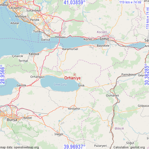
Orhaniye GPS coordinates[2]
40° 30' 21.996" North, 29° 39' 34.992" East
| Map corner | latitude | longitude |
|---|---|---|
| Upper-left | 41.03859°, | 28.9566° |
| Center: | 40.50611°, | 29.65972° |
| Lower-right: | 39.96937°, | 30.36285° |
| Map W x H: | 118.9×118.9 km | = 73.9×73.9mi |
| max Lat: | 42.02683° ⇑22.4% North |
| Orhaniye: | 40.50611° |
| min Lat: | ⇓77.6% South 35.9025° |
| min Long | Orhaniye | max Long |
| 25.90902° | 29.65972° | 44.60099° |
| W 21.9%⇐ | ⇒78.1% E |
Elevation
Elevation of Orhaniye is 167 m = 548 ft, and this is 550.4 m = 1806 ft below average elevation for this country.
| Max E: |
2682 m = 8799 ft | 75.6% |
| Avg. | 717.4 m = 2354 ft | |
| Orhaniye | 167 m = 548 ft | |
Min E: |
0 m = 0 ft | 24.4% |
See also: Turkey elevation on elevation.city.
Geographical zone
Orhaniye is located in North temperate zone (between Tropic of Cancer and the Arctic Circle). Distance of this Northern Tropic circle is 1897.9 km =1179.3 mi to South.| Distance of | km | miles | from Orhaniye |
|---|---|---|---|
| North Pole | 5503.2 | 3419.5 | to North |
| Arctic Circle | 2897.3 | 1800.3 | to North |
| Tropic Cancer | 1897.9 | 1179.3 | to South |
| Equator | 4503.9 | 2798.6 | to South |


Nearby cities:
15 places around Orhaniye: (largest is in red/bold)
• Balarim
15.8 km =9.8 mi,  201°
201°
• Boyalıca
8.8 km =5.5 mi,  252°
252°
• Dereköy
19.4 km =12.1 mi,  335°
335°
• Dırazali
12.9 km =8 mi,  161°
161°
• Elbeyli
5.9 km =3.7 mi,  112°
112°
• Elmalı
18.8 km =11.7 mi,  86°
86°
• Karamürsel
20.9 km =13 mi,  349°
349°
• Kaynarca
17.3 km =10.7 mi,  125°
125°
• Narlıca
20.2 km =12.6 mi,  228°
228°
• Sansarak
14.5 km =9 mi,  97°
97°
• Tacir
7.1 km =4.4 mi,  72°
72°
• Yalakdere
13.9 km =8.6 mi,  323°
323°
• Çakırca
4 km =2.5 mi,  175°
175°
• Çakırlı
17.6 km =10.9 mi,  274°
274°
• İznik
10.1 km =6.3 mi,  148°
148°
Sources, notices
• [Note1] Compared only with cities in Turkey existing in our database
• [Src1] Map data: © OpenStreetMap contributors (CC-BY-SA)
• [Src2] Other city data from geonames.org with taken over terms of usage.
• [Src3] Geographical zone / Annual Mean Temperature by Robert A. Rohde @ Wikipedia
