Gürgentepe geodata
Gürgentepe (Ordu) is a seat of a second-order administrative division; located in Turkey in Europe/Istanbul (GMT+3) time zone. With population of 18,771 people, there are 346 cities with bigger population in this country. Compared to other cities in Turkey, 83.3% of cities are located further ↓South; 59.4% of cities are located further ←West and 82% of cities have lower elevation than Gürgentepe. Note1


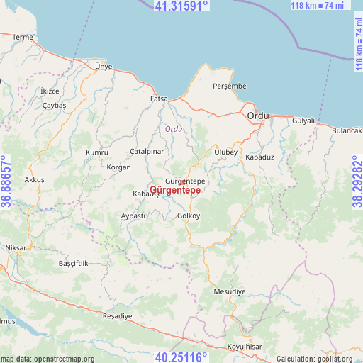
Gürgentepe GPS coordinates[2]
40° 47' 8.412" North, 37° 35' 22.884" East
| Map corner | latitude | longitude |
|---|---|---|
| Upper-left | 41.31591°, | 36.88657° |
| Center: | 40.78567°, | 37.58969° |
| Lower-right: | 40.25116°, | 38.29282° |
| Map W x H: | 118.4×118.4 km | = 73.6×73.6mi |
| max Lat: | 42.02683° ⇑16.7% North |
| Gürgentepe: | 40.78567° |
| min Lat: | ⇓83.3% South 35.9025° |
| min Long | Gürgentepe | max Long |
| 25.90902° | 37.58969° | 44.60099° |
| W 59.4%⇐ | ⇒40.6% E |
Elevation
Elevation of Gürgentepe is 1233 m = 4045 ft, and this is 515.6 m = 1692 ft above average elevation for this country.
| Max E: |
2682 m = 8799 ft | 18% |
| Gürgentepe | 1233 m 4045 ft | |
| Avg. | 717.4 m = 2354 ft | |
Min E: |
0 m = 0 ft | 82% |
See also: Turkey elevation on elevation.city.
Geographical zone
Gürgentepe is located in North temperate zone (between Tropic of Cancer and the Arctic Circle). Distance of this Northern Tropic circle is 1929 km =1198.6 mi to South.| Distance of | km | miles | from Gürgentepe |
|---|---|---|---|
| North Pole | 5472.1 | 3400.2 | to North |
| Arctic Circle | 2866.2 | 1781 | to North |
| Tropic Cancer | 1929 | 1198.6 | to South |
| Equator | 4534.9 | 2817.9 | to South |


Nearby cities:
15 places around Gürgentepe: (largest is in red/bold)
• Altınordu
32.5 km =20.2 mi,  47°
47°
• Aybastı
19.5 km =12.1 mi,  235°
235°
• Bolaman
27.7 km =17.2 mi,  0°
0°
• Fatsa
27.9 km =17.3 mi,  344°
344°
• Gölköy
11.2 km =7 mi,  168°
168°
• Kabadüz
26.2 km =16.3 mi,  71°
71°
• Kabataş
12.4 km =7.7 mi,  251°
251°
• Korgan
20.9 km =13 mi,  281°
281°
• Kumru
29.1 km =18.1 mi,  289°
289°
• Topçam
24.2 km =15 mi,  140°
140°
• Ulubey
16.6 km =10.3 mi,  56°
56°
• Uzunisa
26 km =16.2 mi, 56°
• Yeşilce
32.8 km =20.4 mi,  147°
147°
• Çamaş
13.9 km =8.6 mi, 338°
• Çatalpınar
15.5 km =9.6 mi,  312°
312°
Sources, notices
• [Note1] Compared only with cities in Turkey existing in our database
• [Src1] Map data: © OpenStreetMap contributors (CC-BY-SA)
• [Src2] Other city data from geonames.org with taken over terms of usage.
• [Src3] Geographical zone / Annual Mean Temperature by Robert A. Rohde @ Wikipedia
