Perşembe geodata
Perşembe (Ordu) is a seat of a second-order administrative division; located in Turkey in Europe/Istanbul (GMT+3) time zone. With population of 11,808 people, there are 457 cities with bigger population in this country. Compared to other cities in Turkey, 91.5% of cities are located further ↓South; 60.3% of cities are located further ←West and 88.8% of cities have higher elevation than Perşembe. Note1


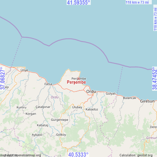
Perşembe GPS coordinates[2]
41° 3' 56.016" North, 37° 46' 17.004" East
| Map corner | latitude | longitude |
|---|---|---|
| Upper-left | 41.59355°, | 37.06827° |
| Center: | 41.06556°, | 37.77139° |
| Lower-right: | 40.5333°, | 38.47452° |
| Map W x H: | 117.9×117.9 km | = 73.3×73.3mi |
| max Lat: | 42.02683° ⇑8.5% North |
| Perşembe: | 41.06556° |
| min Lat: | ⇓91.5% South 35.9025° |
| min Long | Perşembe | max Long |
| 25.90902° | 37.77139° | 44.60099° |
| W 60.3%⇐ | ⇒39.7% E |
Elevation
Elevation of Perşembe is 45 m = 148 ft, and this is 672.4 m = 2206 ft below average elevation for this country.
| Max E: |
2682 m = 8799 ft | 88.8% |
| Avg. | 717.4 m = 2354 ft | |
| Perşembe | 45 m = 148 ft | |
Min E: |
0 m = 0 ft | 11.2% |
See also: Turkey elevation on elevation.city.
Geographical zone
Perşembe is located in North temperate zone (between Tropic of Cancer and the Arctic Circle). Distance of this Northern Tropic circle is 1960.1 km =1217.9 mi to South.| Distance of | km | miles | from Perşembe |
|---|---|---|---|
| North Pole | 5441 | 3380.9 | to North |
| Arctic Circle | 2835.1 | 1761.6 | to North |
| Tropic Cancer | 1960.1 | 1217.9 | to South |
| Equator | 4566.1 | 2837.2 | to South |


Nearby cities:
15 places around Perşembe: (largest is in red/bold)
• Altınordu
12.5 km =7.8 mi,  136°
136°
• Bolaman
15.3 km =9.5 mi,  256°
256°
• Bulancak
41.1 km =25.5 mi,  110°
110°
• Fatsa
23 km =14.3 mi, 259°
• Gülyalı
26 km =16.2 mi,  116°
116°
• Gürgentepe
34.7 km =21.6 mi,  206°
206°
• Kabadüz
24.7 km =15.3 mi,  157°
157°
• Ordu
14 km =8.7 mi,  134°
134°
• Piraziz
31 km =19.3 mi, 113°
• Piraziz
33.6 km =20.9 mi, 118°
• Ulubey
21.9 km =13.6 mi,  183°
183°
• Uzunisa
18 km =11.2 mi, 158°
• Çamaş
27.4 km =17 mi,  228°
228°
• Çatalpınar
33.8 km =21 mi, 232°
• Ünye
41.6 km =25.8 mi,  280°
280°
Sources, notices
• [Note1] Compared only with cities in Turkey existing in our database
• [Src1] Map data: © OpenStreetMap contributors (CC-BY-SA)
• [Src2] Other city data from geonames.org with taken over terms of usage.
• [Src3] Geographical zone / Annual Mean Temperature by Robert A. Rohde @ Wikipedia
