Tonya geodata
Tonya (Trabzon) is a seat of a second-order administrative division; located in Turkey in Europe/Istanbul (GMT+3) time zone. With population of 14,544 people, there are 399 cities with bigger population in this country. Compared to other cities in Turkey, 85.8% of cities are located further ↓South; 69.7% of cities are located further ←West and 56% of cities have lower elevation than Tonya. Note1


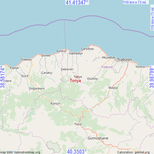
Tonya GPS coordinates[2]
40° 53' 2.472" North, 39° 17' 5.496" East
| Map corner | latitude | longitude |
|---|---|---|
| Upper-left | 41.41347°, | 38.58174° |
| Center: | 40.88402°, | 39.28486° |
| Lower-right: | 40.3503°, | 39.98799° |
| Map W x H: | 118.2×118.2 km | = 73.4×73.4mi |
| max Lat: | 42.02683° ⇑14.2% North |
| Tonya: | 40.88402° |
| min Lat: | ⇓85.8% South 35.9025° |
| min Long | Tonya | max Long |
| 25.90902° | 39.28486° | 44.60099° |
| W 69.7%⇐ | ⇒30.3% E |
Elevation
Elevation of Tonya is 809 m = 2654 ft, and this is 91.6 m = 301 ft above average elevation for this country.
| Max E: |
2682 m = 8799 ft | 44% |
| Tonya | 809 m 2654 ft | |
| Avg. | 717.4 m = 2354 ft | |
Min E: |
0 m = 0 ft | 56% |
See also: Turkey elevation on elevation.city.
Geographical zone
Tonya is located in North temperate zone (between Tropic of Cancer and the Arctic Circle). Distance of this Northern Tropic circle is 1940 km =1205.5 mi to South.| Distance of | km | miles | from Tonya |
|---|---|---|---|
| North Pole | 5461.2 | 3393.4 | to North |
| Arctic Circle | 2855.3 | 1774.2 | to North |
| Tropic Cancer | 1940 | 1205.5 | to South |
| Equator | 4545.9 | 2824.7 | to South |


Nearby cities:
15 places around Tonya: (largest is in red/bold)
• Akçaabat
28.5 km =17.7 mi,  57°
57°
• Beşikdüzü
19.2 km =11.9 mi,  346°
346°
• Derecik
26.9 km =16.7 mi,  75°
75°
• Doğankent
32.1 km =19.9 mi,  254°
254°
• Düzköy
11 km =6.8 mi,  95°
95°
• Esiroğlu
33.9 km =21.1 mi,  92°
92°
• Eynesil
23.3 km =14.5 mi,  329°
329°
• Görele
28.7 km =17.8 mi,  304°
304°
• Kürtün
26.4 km =16.4 mi,  217°
217°
• Maçka
28.1 km =17.5 mi,  106°
106°
• Tosköy
33.4 km =20.8 mi, 79°
• Vakfıkebir
18 km =11.2 mi,  357°
357°
• Çanakçı
25.1 km =15.6 mi,  276°
276°
• Çarşıbaşı
23.6 km =14.7 mi,  20°
20°
• Şalpazarı
10 km =6.2 mi,  307°
307°
Sources, notices
• [Note1] Compared only with cities in Turkey existing in our database
• [Src1] Map data: © OpenStreetMap contributors (CC-BY-SA)
• [Src2] Other city data from geonames.org with taken over terms of usage.
• [Src3] Geographical zone / Annual Mean Temperature by Robert A. Rohde @ Wikipedia
