Akçaabat geodata
Akçaabat (Trabzon) is a seat of a second-order administrative division; located in Turkey in Europe/Istanbul (GMT+3) time zone. With population of 45,105 people, there are 190 cities with bigger population in this country. Compared to other cities in Turkey, 89.9% of cities are located further ↓South; 71.5% of cities are located further ←West and 93.9% of cities have higher elevation than Akçaabat. Note1


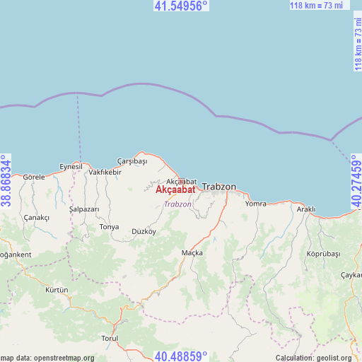
Akçaabat GPS coordinates[2]
41° 1' 16.356" North, 39° 34' 17.256" East
| Map corner | latitude | longitude |
|---|---|---|
| Upper-left | 41.54956°, | 38.86834° |
| Center: | 41.02121°, | 39.57146° |
| Lower-right: | 40.48859°, | 40.27459° |
| Map W x H: | 118×118 km | = 73.3×73.3mi |
| max Lat: | 42.02683° ⇑10.1% North |
| Akçaabat: | 41.02121° |
| min Lat: | ⇓89.9% South 35.9025° |
| min Long | Akçaabat | max Long |
| 25.90902° | 39.57146° | 44.60099° |
| W 71.5%⇐ | ⇒28.5% E |
Elevation
Elevation of Akçaabat is 21 m = 69 ft, and this is 696.4 m = 2285 ft below average elevation for this country.
| Max E: |
2682 m = 8799 ft | 93.9% |
| Avg. | 717.4 m = 2354 ft | |
| Akçaabat | 21 m = 69 ft | |
Min E: |
0 m = 0 ft | 6.1% |
See also: Akçaabat elevation on elevation.city.
Geographical zone
Akçaabat is located in North temperate zone (between Tropic of Cancer and the Arctic Circle). Distance of this Northern Tropic circle is 1955.2 km =1214.9 mi to South.| Distance of | km | miles | from Akçaabat |
|---|---|---|---|
| North Pole | 5445.9 | 3383.9 | to North |
| Arctic Circle | 2840 | 1764.7 | to North |
| Tropic Cancer | 1955.2 | 1214.9 | to South |
| Equator | 4561.1 | 2834.1 | to South |


Nearby cities:
15 places around Akçaabat: (largest is in red/bold)
• Arsin
30.8 km =19.1 mi,  104°
104°
• Beşikdüzü
28.6 km =17.8 mi,  276°
276°
• Derecik
8.6 km =5.3 mi,  167°
167°
• Düzköy
20.9 km =13 mi,  218°
218°
• Esiroğlu
19.1 km =11.9 mi,  149°
149°
• Eynesil
36.3 km =22.6 mi, 277°
• Maçka
23.6 km =14.7 mi, 173°
• Tonya
28.5 km =17.7 mi,  237°
237°
• Tosköy
12.7 km =7.9 mi,  136°
136°
• Trabzon
13.2 km =8.2 mi, 97°
• Vakfıkebir
24.9 km =15.5 mi, 276°
• Yomra
25 km =15.5 mi,  107°
107°
• Çarşıbaşı
17.2 km =10.7 mi,  293°
293°
• Çağlayan
17.9 km =11.1 mi, 138°
• Şalpazarı
33.3 km =20.7 mi,  253°
253°
Sources, notices
• [Note1] Compared only with cities in Turkey existing in our database
• [Src1] Map data: © OpenStreetMap contributors (CC-BY-SA)
• [Src2] Other city data from geonames.org with taken over terms of usage.
• [Src3] Geographical zone / Annual Mean Temperature by Robert A. Rohde @ Wikipedia
