Düzköy geodata
Düzköy (Trabzon) is a seat of a second-order administrative division; located in Turkey in Europe/Istanbul (GMT+3) time zone. With population of 8,090 people, there are 573 cities with bigger population in this country. Compared to other cities in Turkey, 85.5% of cities are located further ↓South; 70.6% of cities are located further ←West and 50.9% of cities have lower elevation than Düzköy. Note1


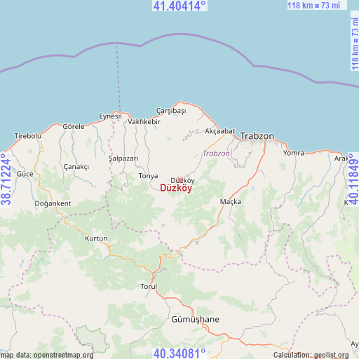
Düzköy GPS coordinates[2]
40° 52' 28.596" North, 39° 24' 55.296" East
| Map corner | latitude | longitude |
|---|---|---|
| Upper-left | 41.40414°, | 38.71224° |
| Center: | 40.87461°, | 39.41536° |
| Lower-right: | 40.34081°, | 40.11849° |
| Map W x H: | 118.2×118.2 km | = 73.4×73.4mi |
| max Lat: | 42.02683° ⇑14.5% North |
| Düzköy: | 40.87461° |
| min Lat: | ⇓85.5% South 35.9025° |
| min Long | Düzköy | max Long |
| 25.90902° | 39.41536° | 44.60099° |
| W 70.6%⇐ | ⇒29.4% E |
Elevation
Elevation of Düzköy is 713 m = 2339 ft, and this is 4.4 m = 14 ft below average elevation for this country.
| Max E: |
2682 m = 8799 ft | 49.1% |
| Avg. | 717.4 m = 2354 ft | |
| Düzköy | 713 m = 2339 ft | |
Min E: |
0 m = 0 ft | 50.9% |
See also: Turkey elevation on elevation.city.
Geographical zone
Düzköy is located in North temperate zone (between Tropic of Cancer and the Arctic Circle). Distance of this Northern Tropic circle is 1938.9 km =1204.8 mi to South.| Distance of | km | miles | from Düzköy |
|---|---|---|---|
| North Pole | 5462.2 | 3394.1 | to North |
| Arctic Circle | 2856.3 | 1774.8 | to North |
| Tropic Cancer | 1938.9 | 1204.8 | to South |
| Equator | 4544.8 | 2824 | to South |


Nearby cities:
15 places around Düzköy: (largest is in red/bold)
• Akçaabat
20.9 km =13 mi,  38°
38°
• Beşikdüzü
25 km =15.5 mi,  322°
322°
• Derecik
17 km =10.6 mi,  62°
62°
• Esiroğlu
22.9 km =14.2 mi,  90°
90°
• Eynesil
31.1 km =19.3 mi,  312°
312°
• Kürtün
33.6 km =20.9 mi,  233°
233°
• Maçka
17.4 km =10.8 mi,  114°
114°
• Tonya
11 km =6.8 mi,  275°
275°
• Tosköy
23 km =14.3 mi,  71°
71°
• Trabzon
29.9 km =18.6 mi, 61°
• Vakfıkebir
22.3 km =13.9 mi,  328°
328°
• Çanakçı
36.1 km =22.4 mi, 276°
• Çarşıbaşı
23.3 km =14.5 mi,  353°
353°
• Çağlayan
25.1 km =15.6 mi,  83°
83°
• Şalpazarı
20.2 km =12.6 mi,  290°
290°
Sources, notices
• [Note1] Compared only with cities in Turkey existing in our database
• [Src1] Map data: © OpenStreetMap contributors (CC-BY-SA)
• [Src2] Other city data from geonames.org with taken over terms of usage.
• [Src3] Geographical zone / Annual Mean Temperature by Robert A. Rohde @ Wikipedia
