Sultanköy geodata
Sultanköy (Tekirdağ) is a populated place; located in Turkey in Europe/Istanbul (GMT+3) time zone. With population of 2,708 people, there are 879 cities with bigger population in this country. Compared to other cities in Turkey, 89.9% of cities are located further ↓South; 90.3% of cities are located further →East and 92.3% of cities have higher elevation than Sultanköy. Note1


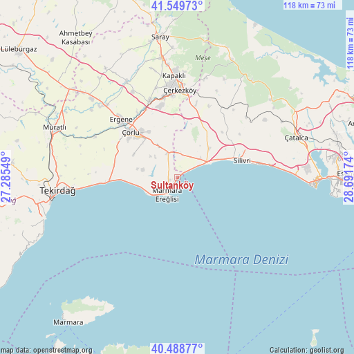
Sultanköy GPS coordinates[2]
41° 1' 17.004" North, 27° 59' 18.996" East
| Map corner | latitude | longitude |
|---|---|---|
| Upper-left | 41.54973°, | 27.28549° |
| Center: | 41.02139°, | 27.98861° |
| Lower-right: | 40.48877°, | 28.69174° |
| Map W x H: | 118×118 km | = 73.3×73.3mi |
| max Lat: | 42.02683° ⇑10.1% North |
| Sultanköy: | 41.02139° |
| min Lat: | ⇓89.9% South 35.9025° |
| min Long | Sultanköy | max Long |
| 25.90902° | 27.98861° | 44.60099° |
| W 9.7%⇐ | ⇒90.3% E |
Elevation
Elevation of Sultanköy is 27 m = 89 ft, and this is 690.4 m = 2265 ft below average elevation for this country.
| Max E: |
2682 m = 8799 ft | 92.3% |
| Avg. | 717.4 m = 2354 ft | |
| Sultanköy | 27 m = 89 ft | |
Min E: |
0 m = 0 ft | 7.7% |
See also: Turkey elevation on elevation.city.
Geographical zone
Sultanköy is located in North temperate zone (between Tropic of Cancer and the Arctic Circle). Distance of this Northern Tropic circle is 1955.2 km =1214.9 mi to South.| Distance of | km | miles | from Sultanköy |
|---|---|---|---|
| North Pole | 5445.9 | 3383.9 | to North |
| Arctic Circle | 2840 | 1764.7 | to North |
| Tropic Cancer | 1955.2 | 1214.9 | to South |
| Equator | 4561.2 | 2834.2 | to South |


Nearby cities:
15 places around Sultanköy: (largest is in red/bold)
• Büyük Sinekli
29.5 km =18.3 mi,  39°
39°
• Büyükçavuşlu
25.1 km =15.6 mi,  14°
14°
• Celâliye
36.2 km =22.5 mi,  84°
84°
• Kapaklı
34.2 km =21.3 mi,  358°
358°
• Kavaklı
29.8 km =18.5 mi,  74°
74°
• Marmara Ereğlisi
6.4 km =4 mi,  206°
206°
• Marmaracık
28.4 km =17.6 mi,  316°
316°
• Ortaköy
33.7 km =20.9 mi, 74°
• Selimpaşa
31.9 km =19.8 mi, 83°
• Silivri
22.4 km =13.9 mi, 74°
• Sinekli
28.5 km =17.7 mi, 36°
• Velimeşe
27.4 km =17 mi,  340°
340°
• Çanta
10.2 km =6.3 mi,  51°
51°
• Çerkezköy
29.5 km =18.3 mi,  1°
1°
• Çorlu
22 km =13.7 mi,  314°
314°
Sources, notices
• [Note1] Compared only with cities in Turkey existing in our database
• [Src1] Map data: © OpenStreetMap contributors (CC-BY-SA)
• [Src2] Other city data from geonames.org with taken over terms of usage.
• [Src3] Geographical zone / Annual Mean Temperature by Robert A. Rohde @ Wikipedia
