Çorlu geodata
Çorlu (Tekirdağ) is a seat of a second-order administrative division; located in Turkey in Europe/Istanbul (GMT+3) time zone. With population of 202,578 people, there are 50 cities with bigger population in this country. Compared to other cities in Turkey, 93.3% of cities are located further ↓South; 91.5% of cities are located further →East and 75.2% of cities have higher elevation than Çorlu. Note1


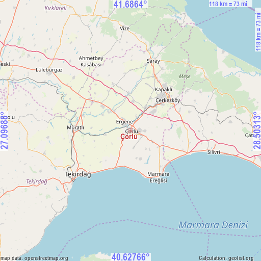
Çorlu GPS coordinates[2]
41° 9' 33.012" North, 27° 48' 0" East
| Map corner | latitude | longitude |
|---|---|---|
| Upper-left | 41.6864°, | 27.09688° |
| Center: | 41.15917°, | 27.8° |
| Lower-right: | 40.62766°, | 28.50313° |
| Map W x H: | 117.7×117.7 km | = 73.1×73.1mi |
| max Lat: | 42.02683° ⇑6.7% North |
| Çorlu: | 41.15917° |
| min Lat: | ⇓93.3% South 35.9025° |
| min Long | Çorlu | max Long |
| 25.90902° | 27.8° | 44.60099° |
| W 8.5%⇐ | ⇒91.5% E |
Elevation
Elevation of Çorlu is 172 m = 564 ft, and this is 545.4 m = 1789 ft below average elevation for this country.
| Max E: |
2682 m = 8799 ft | 75.2% |
| Avg. | 717.4 m = 2354 ft | |
| Çorlu | 172 m = 564 ft | |
Min E: |
0 m = 0 ft | 24.8% |
See also: Çorlu elevation on elevation.city.
Geographical zone
Çorlu is located in North temperate zone (between Tropic of Cancer and the Arctic Circle). Distance of this Northern Tropic circle is 1970.6 km =1224.5 mi to South.| Distance of | km | miles | from Çorlu |
|---|---|---|---|
| North Pole | 5430.6 | 3374.4 | to North |
| Arctic Circle | 2824.7 | 1755.2 | to North |
| Tropic Cancer | 1970.6 | 1224.5 | to South |
| Equator | 4576.5 | 2843.7 | to South |


Nearby cities:
15 places around Çorlu: (largest is in red/bold)
• Beyazköy
22.5 km =14 mi,  339°
339°
• Büyük Sinekli
35.3 km =21.9 mi,  77°
77°
• Büyükkarıştıran
26.5 km =16.5 mi,  306°
306°
• Büyükçavuşlu
23.8 km =14.8 mi,  67°
67°
• Kapaklı
24.2 km =15 mi,  38°
38°
• Marmara Ereğlisi
24.7 km =15.3 mi,  148°
148°
• Marmaracık
6.5 km =4 mi,  324°
324°
• Muratlı
25.2 km =15.7 mi,  273°
273°
• Saray
33.3 km =20.7 mi,  17°
17°
• Sinekli
33.6 km =20.9 mi, 76°
• Sultanköy
22 km =13.7 mi,  134°
134°
• Tekirdağ
31.5 km =19.6 mi,  230°
230°
• Velimeşe
12.4 km =7.7 mi,  31°
31°
• Çanta
25.3 km =15.7 mi,  110°
110°
• Çerkezköy
21.9 km =13.6 mi,  49°
49°
Sources, notices
• [Note1] Compared only with cities in Turkey existing in our database
• [Src1] Map data: © OpenStreetMap contributors (CC-BY-SA)
• [Src2] Other city data from geonames.org with taken over terms of usage.
• [Src3] Geographical zone / Annual Mean Temperature by Robert A. Rohde @ Wikipedia
