Kavaklı geodata
Kavaklı (Istanbul) is a populated place; located in Turkey in Europe/Istanbul (GMT+3) time zone. With population of 50,502 people, there are 170 cities with bigger population in this country. Compared to other cities in Turkey, 92.1% of cities are located further ↓South; 88% of cities are located further →East and 83.9% of cities have higher elevation than Kavaklı. Note1


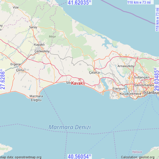
Kavaklı GPS coordinates[2]
41° 5' 33.288" North, 28° 19' 54.192" East
| Map corner | latitude | longitude |
|---|---|---|
| Upper-left | 41.62035°, | 27.6286° |
| Center: | 41.09258°, | 28.33172° |
| Lower-right: | 40.56054°, | 29.03485° |
| Map W x H: | 117.8×117.8 km | = 73.2×73.2mi |
| max Lat: | 42.02683° ⇑7.9% North |
| Kavaklı: | 41.09258° |
| min Lat: | ⇓92.1% South 35.9025° |
| min Long | Kavaklı | max Long |
| 25.90902° | 28.33172° | 44.60099° |
| W 12%⇐ | ⇒88% E |
Elevation
Elevation of Kavaklı is 81 m = 266 ft, and this is 636.4 m = 2088 ft below average elevation for this country.
| Max E: |
2682 m = 8799 ft | 83.9% |
| Avg. | 717.4 m = 2354 ft | |
| Kavaklı | 81 m = 266 ft | |
Min E: |
0 m = 0 ft | 16.1% |
See also: Kavaklı elevation on elevation.city.
Geographical zone
Kavaklı is located in North temperate zone (between Tropic of Cancer and the Arctic Circle). Distance of this Northern Tropic circle is 1963.1 km =1219.8 mi to South.| Distance of | km | miles | from Kavaklı |
|---|---|---|---|
| North Pole | 5438 | 3379 | to North |
| Arctic Circle | 2832.1 | 1759.8 | to North |
| Tropic Cancer | 1963.1 | 1219.8 | to South |
| Equator | 4569.1 | 2839.1 | to South |


Nearby cities:
15 places around Kavaklı: (largest is in red/bold)
• Büyük Sinekli
17.8 km =11.1 mi,  326°
326°
• Büyükçekmece
22.7 km =14.1 mi,  110°
110°
• Celâliye
8.6 km =5.3 mi,  121°
121°
• Chekmejeh
19.5 km =12.1 mi, 117°
• Gürpınar
26.2 km =16.3 mi, 115°
• Kumburgaz
14.8 km =9.2 mi, 122°
• Mimarsinan
21 km =13 mi, 113°
• Muratbey
13.5 km =8.4 mi,  88°
88°
• Ortaköy
3.8 km =2.4 mi,  74°
74°
• Selimpaşa
5.2 km =3.2 mi,  145°
145°
• Silivri
7.4 km =4.6 mi,  253°
253°
• Sinekli
19.1 km =11.9 mi,  321°
321°
• Tepecik
19.6 km =12.2 mi, 111°
• Çanta
20.9 km =13 mi,  265°
265°
• Çatalca
12.2 km =7.6 mi,  62°
62°
Sources, notices
• [Note1] Compared only with cities in Turkey existing in our database
• [Src1] Map data: © OpenStreetMap contributors (CC-BY-SA)
• [Src2] Other city data from geonames.org with taken over terms of usage.
• [Src3] Geographical zone / Annual Mean Temperature by Robert A. Rohde @ Wikipedia
