Kapaklı geodata
Kapaklı (Tekirdağ) is a seat of a second-order administrative division; located in Turkey in Europe/Istanbul (GMT+3) time zone. In our database, there are 1323 cities with bigger population. Compared to other cities in Turkey, 95.9% of cities are located further ↓South; 90.4% of cities are located further →East and 73.8% of cities have higher elevation than Kapaklı. Note1


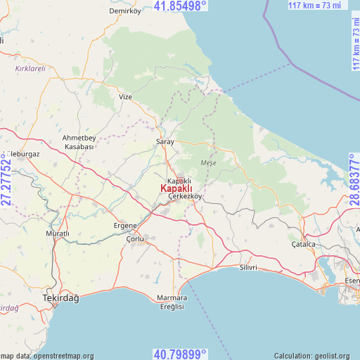
Kapaklı GPS coordinates[2]
41° 19' 44.832" North, 27° 58' 50.304" East
| Map corner | latitude | longitude |
|---|---|---|
| Upper-left | 41.85498°, | 27.27752° |
| Center: | 41.32912°, | 27.98064° |
| Lower-right: | 40.79899°, | 28.68377° |
| Map W x H: | 117.4×117.4 km | = 72.9×72.9mi |
| max Lat: | 42.02683° ⇑4.1% North |
| Kapaklı: | 41.32912° |
| min Lat: | ⇓95.9% South 35.9025° |
| min Long | Kapaklı | max Long |
| 25.90902° | 27.98064° | 44.60099° |
| W 9.6%⇐ | ⇒90.4% E |
Elevation
Elevation of Kapaklı is 197 m = 646 ft, and this is 520.4 m = 1707 ft below average elevation for this country.
| Max E: |
2682 m = 8799 ft | 73.8% |
| Avg. | 717.4 m = 2354 ft | |
| Kapaklı | 197 m = 646 ft | |
Min E: |
0 m = 0 ft | 26.2% |
See also: Turkey elevation on elevation.city.
Geographical zone
Kapaklı is located in North temperate zone (between Tropic of Cancer and the Arctic Circle). Distance of this Northern Tropic circle is 1989.4 km =1236.2 mi to South.| Distance of | km | miles | from Kapaklı |
|---|---|---|---|
| North Pole | 5411.7 | 3362.7 | to North |
| Arctic Circle | 2805.8 | 1743.4 | to North |
| Tropic Cancer | 1989.4 | 1236.2 | to South |
| Equator | 4595.4 | 2855.4 | to South |


Nearby cities:
15 places around Kapaklı: (largest is in red/bold)
• Beyazköy
23.2 km =14.4 mi,  275°
275°
• Büyük Sinekli
22.6 km =14 mi,  120°
120°
• Büyükçavuşlu
12.1 km =7.5 mi,  145°
145°
• Karacaköy
34.4 km =21.4 mi,  76°
76°
• Marmaracık
23.3 km =14.5 mi,  234°
234°
• Salmydessus
35.3 km =21.9 mi,  15°
15°
• Saray
13.7 km =8.5 mi,  339°
339°
• Silivri
36 km =22.4 mi,  141°
141°
• Sinekli
20.8 km =12.9 mi, 122°
• Sultanköy
34.2 km =21.3 mi,  178°
178°
• Velimeşe
12 km =7.5 mi, 225°
• Vize
32.4 km =20.1 mi,  326°
326°
• Çanta
29.1 km =18.1 mi,  162°
162°
• Çerkezköy
5 km =3.1 mi, 161°
• Çorlu
24.2 km =15 mi,  218°
218°
Sources, notices
• [Note1] Compared only with cities in Turkey existing in our database
• [Src1] Map data: © OpenStreetMap contributors (CC-BY-SA)
• [Src2] Other city data from geonames.org with taken over terms of usage.
• [Src3] Geographical zone / Annual Mean Temperature by Robert A. Rohde @ Wikipedia
