Celâliye geodata
Celâliye (Istanbul) is a populated place; located in Turkey in Europe/Istanbul (GMT+3) time zone. With population of 7,788 people, there are 585 cities with bigger population in this country. Compared to other cities in Turkey, 90.9% of cities are located further ↓South; 87.4% of cities are located further →East and 87.3% of cities have higher elevation than Celâliye. Note1


Celâliye GPS coordinates[2]
41° 3' 6.768" North, 28° 25' 7.212" East
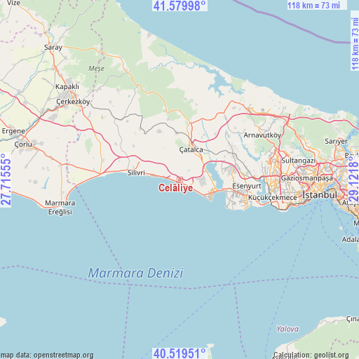
| Map corner | latitude | longitude |
|---|---|---|
| Upper-left | 41.57998°, | 27.71555° |
| Center: | 41.05188°, | 28.41867° |
| Lower-right: | 40.51951°, | 29.1218° |
| Map W x H: | 117.9×117.9 km | = 73.3×73.3mi |
| max Lat: | 42.02683° ⇑9.1% North |
| Celâliye: | 41.05188° |
| min Lat: | ⇓90.9% South 35.9025° |
| min Long | Celâliye | max Long |
| 25.90902° | 28.41867° | 44.60099° |
| W 12.6%⇐ | ⇒87.4% E |
Elevation
Elevation of Celâliye is 57 m = 187 ft, and this is 660.4 m = 2167 ft below average elevation for this country.
| Max E: |
2682 m = 8799 ft | 87.3% |
| Avg. | 717.4 m = 2354 ft | |
| Celâliye | 57 m = 187 ft | |
Min E: |
0 m = 0 ft | 12.7% |
See also: Turkey elevation on elevation.city.
Geographical zone
Celâliye is located in North temperate zone (between Tropic of Cancer and the Arctic Circle). Distance of this Northern Tropic circle is 1958.6 km =1217 mi to South.| Distance of | km | miles | from Celâliye |
|---|---|---|---|
| North Pole | 5442.5 | 3381.8 | to North |
| Arctic Circle | 2836.6 | 1762.6 | to North |
| Tropic Cancer | 1958.6 | 1217 | to South |
| Equator | 4564.5 | 2836.2 | to South |


Nearby cities:
15 places around Celâliye: (largest is in red/bold)
• Beylikdüzü
20.1 km =12.5 mi,  112°
112°
• Büyükçekmece
14.4 km =8.9 mi,  103°
103°
• Chekmejeh
10.9 km =6.8 mi, 113°
• Esenyurt
21.9 km =13.6 mi, 97°
• Gürpınar
17.7 km =11 mi, 111°
• Kavaklı
8.6 km =5.3 mi,  301°
301°
• Kumburgaz
6.2 km =3.9 mi,  123°
123°
• Mimarsinan
12.6 km =7.8 mi, 107°
• Muratbey
7.9 km =4.9 mi,  51°
51°
• Ortaköy
6.6 km =4.1 mi,  326°
326°
• Selimpaşa
4.4 km =2.7 mi,  273°
273°
• Silivri
14.6 km =9.1 mi,  279°
279°
• Tepecik
11.3 km =7 mi, 102°
• Yakuplu
22.7 km =14.1 mi, 107°
• Çatalca
10.8 km =6.7 mi,  19°
19°
Sources, notices
• [Note1] Compared only with cities in Turkey existing in our database
• [Src1] Map data: © OpenStreetMap contributors (CC-BY-SA)
• [Src2] Other city data from geonames.org with taken over terms of usage.
• [Src3] Geographical zone / Annual Mean Temperature by Robert A. Rohde @ Wikipedia
