Çanta geodata
Çanta (Istanbul) is a populated place; located in Turkey in Europe/Istanbul (GMT+3) time zone. With population of 5,470 people, there are 690 cities with bigger population in this country. Compared to other cities in Turkey, 91.9% of cities are located further ↓South; 89.5% of cities are located further →East and 82.7% of cities have higher elevation than Çanta. Note1


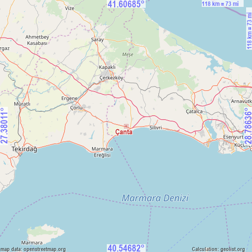
Çanta GPS coordinates[2]
41° 4' 44.292" North, 28° 4' 59.628" East
| Map corner | latitude | longitude |
|---|---|---|
| Upper-left | 41.60685°, | 27.38011° |
| Center: | 41.07897°, | 28.08323° |
| Lower-right: | 40.54682°, | 28.78636° |
| Map W x H: | 117.9×117.9 km | = 73.3×73.3mi |
| max Lat: | 42.02683° ⇑8.1% North |
| Çanta: | 41.07897° |
| min Lat: | ⇓91.9% South 35.9025° |
| min Long | Çanta | max Long |
| 25.90902° | 28.08323° | 44.60099° |
| W 10.5%⇐ | ⇒89.5% E |
Elevation
Elevation of Çanta is 88 m = 289 ft, and this is 629.4 m = 2065 ft below average elevation for this country.
| Max E: |
2682 m = 8799 ft | 82.7% |
| Avg. | 717.4 m = 2354 ft | |
| Çanta | 88 m = 289 ft | |
Min E: |
0 m = 0 ft | 17.3% |
See also: Turkey elevation on elevation.city.
Geographical zone
Çanta is located in North temperate zone (between Tropic of Cancer and the Arctic Circle). Distance of this Northern Tropic circle is 1961.6 km =1218.9 mi to South.| Distance of | km | miles | from Çanta |
|---|---|---|---|
| North Pole | 5439.5 | 3379.9 | to North |
| Arctic Circle | 2833.6 | 1760.7 | to North |
| Tropic Cancer | 1961.6 | 1218.9 | to South |
| Equator | 4567.6 | 2838.2 | to South |


Nearby cities:
15 places around Çanta: (largest is in red/bold)
• Büyük Sinekli
19.6 km =12.2 mi,  33°
33°
• Büyükçavuşlu
18 km =11.2 mi,  354°
354°
• Celâliye
28.3 km =17.6 mi,  96°
96°
• Kapaklı
29.1 km =18.1 mi,  342°
342°
• Kavaklı
20.9 km =13 mi,  85°
85°
• Marmara Ereğlisi
16.2 km =10.1 mi,  221°
221°
• Marmaracık
31 km =19.3 mi,  297°
297°
• Ortaköy
24.7 km =15.3 mi,  84°
84°
• Selimpaşa
23.9 km =14.9 mi, 96°
• Silivri
13.7 km =8.5 mi, 92°
• Sinekli
18.8 km =11.7 mi, 28°
• Sultanköy
10.2 km =6.3 mi,  231°
231°
• Velimeşe
25.9 km =16.1 mi,  318°
318°
• Çerkezköy
24.1 km =15 mi, 343°
• Çorlu
25.3 km =15.7 mi,  290°
290°
Sources, notices
• [Note1] Compared only with cities in Turkey existing in our database
• [Src1] Map data: © OpenStreetMap contributors (CC-BY-SA)
• [Src2] Other city data from geonames.org with taken over terms of usage.
• [Src3] Geographical zone / Annual Mean Temperature by Robert A. Rohde @ Wikipedia
