Ardanuç geodata
Ardanuç (Artvin) is a seat of a second-order administrative division; located in Turkey in Europe/Istanbul (GMT+3) time zone. With population of 5,318 people, there are 697 cities with bigger population in this country. Compared to other cities in Turkey, 92.8% of cities are located further ↓South; 90.8% of cities are located further ←West and 62.2% of cities have higher elevation than Ardanuç. Note1


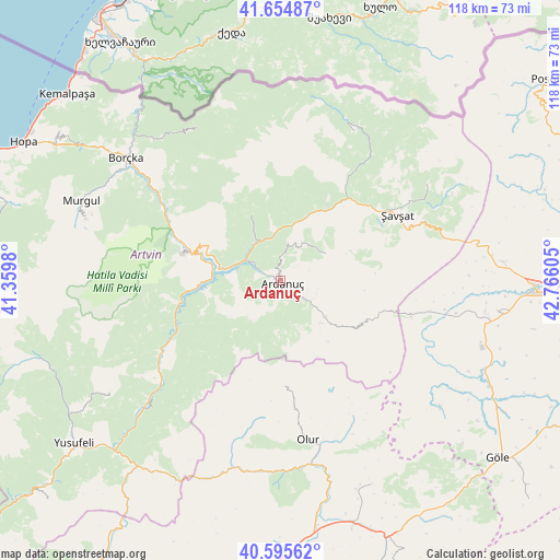
Ardanuç GPS coordinates[2]
41° 7' 38.568" North, 42° 3' 46.512" East
| Map corner | latitude | longitude |
|---|---|---|
| Upper-left | 41.65487°, | 41.3598° |
| Center: | 41.12738°, | 42.06292° |
| Lower-right: | 40.59562°, | 42.76605° |
| Map W x H: | 117.8×117.8 km | = 73.2×73.2mi |
| max Lat: | 42.02683° ⇑7.2% North |
| Ardanuç: | 41.12738° |
| min Lat: | ⇓92.8% South 35.9025° |
| min Long | Ardanuç | max Long |
| 25.90902° | 42.06292° | 44.60099° |
| W 90.8%⇐ | ⇒9.2% E |
Elevation
Elevation of Ardanuç is 469 m = 1539 ft, and this is 248.4 m = 815 ft below average elevation for this country.
| Max E: |
2682 m = 8799 ft | 62.2% |
| Avg. | 717.4 m = 2354 ft | |
| Ardanuç | 469 m = 1539 ft | |
Min E: |
0 m = 0 ft | 37.8% |
See also: Turkey elevation on elevation.city.
Geographical zone
Ardanuç is located in North temperate zone (between Tropic of Cancer and the Arctic Circle). Distance of this Northern Tropic circle is 1967 km =1222.2 mi to South.| Distance of | km | miles | from Ardanuç |
|---|---|---|---|
| North Pole | 5434.1 | 3376.6 | to North |
| Arctic Circle | 2828.2 | 1757.4 | to North |
| Tropic Cancer | 1967 | 1222.2 | to South |
| Equator | 4572.9 | 2841.5 | to South |


Nearby cities:
15 places around Ardanuç: (largest is in red/bold)
• Artvin
21.1 km =13.1 mi,  286°
286°
• Aşağı Irmaklar
11.2 km =7 mi,  56°
56°
• Borçka
41.9 km =26 mi,  307°
307°
• Camili
41.4 km =25.7 mi,  340°
340°
• Demirkent
39.3 km =24.4 mi,  225°
225°
• Meydancık
34.6 km =21.5 mi,  24°
24°
• Murgul
45.7 km =28.4 mi, 291°
• Olur
34.5 km =21.4 mi,  170°
170°
• Ortaköy
15.3 km =9.5 mi,  334°
334°
• Seyitler
20.3 km =12.6 mi, 291°
• Veliköy
37.3 km =23.2 mi, 55°
• Yalnızçam
37.4 km =23.2 mi,  100°
100°
• Zeytinlik
17.3 km =10.7 mi,  263°
263°
• Öğdem
42.8 km =26.6 mi,  236°
236°
• Şavşat
27.9 km =17.3 mi, 63°
Sources, notices
• [Note1] Compared only with cities in Turkey existing in our database
• [Src1] Map data: © OpenStreetMap contributors (CC-BY-SA)
• [Src2] Other city data from geonames.org with taken over terms of usage.
• [Src3] Geographical zone / Annual Mean Temperature by Robert A. Rohde @ Wikipedia
