Saray geodata
Saray (Tekirdağ) is a seat of a second-order administrative division; located in Turkey in Europe/Istanbul (GMT+3) time zone. In our database, there are 1323 cities with bigger population. Compared to other cities in Turkey, 96.9% of cities are located further ↓South; 90.8% of cities are located further →East and 75.8% of cities have higher elevation than Saray. Note1


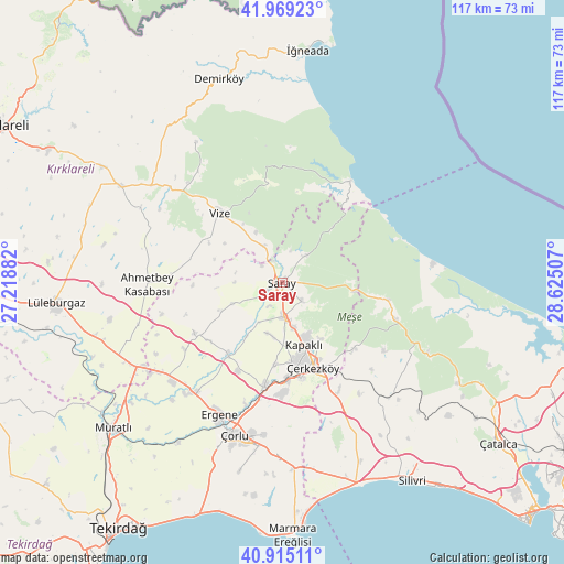
Saray GPS coordinates[2]
41° 26' 39.516" North, 27° 55' 18.984" East
| Map corner | latitude | longitude |
|---|---|---|
| Upper-left | 41.96923°, | 27.21882° |
| Center: | 41.44431°, | 27.92194° |
| Lower-right: | 40.91511°, | 28.62507° |
| Map W x H: | 117.2×117.2 km | = 72.8×72.8mi |
| max Lat: | 42.02683° ⇑3.1% North |
| Saray: | 41.44431° |
| min Lat: | ⇓96.9% South 35.9025° |
| min Long | Saray | max Long |
| 25.90902° | 27.92194° | 44.60099° |
| W 9.2%⇐ | ⇒90.8% E |
Elevation
Elevation of Saray is 165 m = 541 ft, and this is 552.4 m = 1812 ft below average elevation for this country.
| Max E: |
2682 m = 8799 ft | 75.8% |
| Avg. | 717.4 m = 2354 ft | |
| Saray | 165 m = 541 ft | |
Min E: |
0 m = 0 ft | 24.2% |
See also: Turkey elevation on elevation.city.
Geographical zone
Saray is located in North temperate zone (between Tropic of Cancer and the Arctic Circle). Distance of this Northern Tropic circle is 2002.3 km =1244.2 mi to South.| Distance of | km | miles | from Saray |
|---|---|---|---|
| North Pole | 5398.9 | 3354.7 | to North |
| Arctic Circle | 2793 | 1735.5 | to North |
| Tropic Cancer | 2002.3 | 1244.2 | to South |
| Equator | 4608.2 | 2863.4 | to South |


Nearby cities:
15 places around Saray: (largest is in red/bold)
• Beyazköy
21.1 km =13.1 mi,  239°
239°
• Büyük Sinekli
34.4 km =21.4 mi,  135°
135°
• Büyükkarıştıran
35.3 km =21.9 mi, 242°
• Büyükçavuşlu
25.6 km =15.9 mi,  152°
152°
• Kapaklı
13.7 km =8.5 mi,  159°
159°
• Karacaköy
38.5 km =23.9 mi,  96°
96°
• Marmaracık
29.9 km =18.6 mi,  207°
207°
• Pınarhisar
39 km =24.2 mi,  300°
300°
• Salmydessus
25.6 km =15.9 mi,  34°
34°
• Sergen
34 km =21.1 mi,  328°
328°
• Sinekli
32.9 km =20.4 mi, 137°
• Velimeşe
21.5 km =13.4 mi,  189°
189°
• Vize
19.3 km =12 mi,  317°
317°
• Çerkezköy
18.7 km =11.6 mi, 159°
• Çorlu
33.3 km =20.7 mi,  197°
197°
Sources, notices
• [Note1] Compared only with cities in Turkey existing in our database
• [Src1] Map data: © OpenStreetMap contributors (CC-BY-SA)
• [Src2] Other city data from geonames.org with taken over terms of usage.
• [Src3] Geographical zone / Annual Mean Temperature by Robert A. Rohde @ Wikipedia
