Niksar geodata
Niksar (Tokat) is a seat of a second-order administrative division; located in Turkey in Europe/Istanbul (GMT+3) time zone. With population of 49,865 people, there are 175 cities with bigger population in this country. Compared to other cities in Turkey, 78.8% of cities are located further ↓South; 56.7% of cities are located further ←West and 67.4% of cities have higher elevation than Niksar. Note1


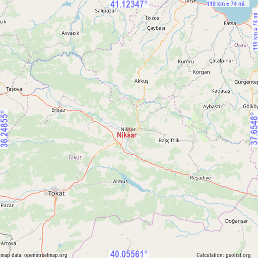
Niksar GPS coordinates[2]
40° 35' 30.012" North, 36° 57' 6.012" East
| Map corner | latitude | longitude |
|---|---|---|
| Upper-left | 41.12347°, | 36.24855° |
| Center: | 40.59167°, | 36.95167° |
| Lower-right: | 40.05561°, | 37.6548° |
| Map W x H: | 118.7×118.7 km | = 73.8×73.8mi |
| max Lat: | 42.02683° ⇑21.2% North |
| Niksar: | 40.59167° |
| min Lat: | ⇓78.8% South 35.9025° |
| min Long | Niksar | max Long |
| 25.90902° | 36.95167° | 44.60099° |
| W 56.7%⇐ | ⇒43.3% E |
Elevation
Elevation of Niksar is 369 m = 1211 ft, and this is 348.4 m = 1143 ft below average elevation for this country.
| Max E: |
2682 m = 8799 ft | 67.4% |
| Avg. | 717.4 m = 2354 ft | |
| Niksar | 369 m = 1211 ft | |
Min E: |
0 m = 0 ft | 32.6% |
See also: Niksar elevation on elevation.city.
Geographical zone
Niksar is located in North temperate zone (between Tropic of Cancer and the Arctic Circle). Distance of this Northern Tropic circle is 1907.5 km =1185.3 mi to South.| Distance of | km | miles | from Niksar |
|---|---|---|---|
| North Pole | 5493.7 | 3413.6 | to North |
| Arctic Circle | 2887.8 | 1794.4 | to North |
| Tropic Cancer | 1907.5 | 1185.3 | to South |
| Equator | 4513.4 | 2804.5 | to South |


Nearby cities:
15 places around Niksar: (largest is in red/bold)
• Akkuş
23 km =14.3 mi,  13°
13°
• Almus
24.3 km =15.1 mi,  189°
189°
• Aybastı
39.2 km =24.4 mi,  74°
74°
• Başçiftlik
19 km =11.8 mi,  105°
105°
• Bereketli
29.8 km =18.5 mi, 107°
• Doğanyurt
22.6 km =14 mi,  298°
298°
• Erbaa
33.5 km =20.8 mi,  284°
284°
• Gökdere
21.4 km =13.3 mi,  231°
231°
• Gökçeli
18.5 km =11.5 mi,  267°
267°
• Karayaka
34.9 km =21.7 mi, 299°
• Korgan
42.2 km =26.2 mi,  52°
52°
• Kozlu
40 km =24.9 mi, 272°
• Kumru
41 km =25.5 mi,  39°
39°
• Reşadiye
39.5 km =24.5 mi,  124°
124°
• Çamiçi
5.1 km =3.2 mi,  55°
55°
Sources, notices
• [Note1] Compared only with cities in Turkey existing in our database
• [Src1] Map data: © OpenStreetMap contributors (CC-BY-SA)
• [Src2] Other city data from geonames.org with taken over terms of usage.
• [Src3] Geographical zone / Annual Mean Temperature by Robert A. Rohde @ Wikipedia
