Karayaka geodata
Karayaka (Tokat) is a seat of a third-order administrative division; located in Turkey in Europe/Istanbul (GMT+3) time zone. In our database, there are 1323 cities with bigger population. Compared to other cities in Turkey, 82.2% of cities are located further ↓South; 55.3% of cities are located further ←West and 68.3% of cities have higher elevation than Karayaka. Note1


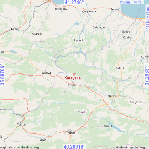
Karayaka GPS coordinates[2]
40° 44' 38.472" North, 36° 35' 24.648" East
| Map corner | latitude | longitude |
|---|---|---|
| Upper-left | 41.2746°, | 35.88706° |
| Center: | 40.74402°, | 36.59018° |
| Lower-right: | 40.20918°, | 37.29331° |
| Map W x H: | 118.5×118.5 km | = 73.6×73.6mi |
| max Lat: | 42.02683° ⇑17.8% North |
| Karayaka: | 40.74402° |
| min Lat: | ⇓82.2% South 35.9025° |
| min Long | Karayaka | max Long |
| 25.90902° | 36.59018° | 44.60099° |
| W 55.3%⇐ | ⇒44.7% E |
Elevation
Elevation of Karayaka is 355 m = 1165 ft, and this is 362.4 m = 1189 ft below average elevation for this country.
| Max E: |
2682 m = 8799 ft | 68.3% |
| Avg. | 717.4 m = 2354 ft | |
| Karayaka | 355 m = 1165 ft | |
Min E: |
0 m = 0 ft | 31.7% |
See also: Turkey elevation on elevation.city.
Geographical zone
Karayaka is located in North temperate zone (between Tropic of Cancer and the Arctic Circle). Distance of this Northern Tropic circle is 1924.4 km =1195.8 mi to South.| Distance of | km | miles | from Karayaka |
|---|---|---|---|
| North Pole | 5476.8 | 3403.1 | to North |
| Arctic Circle | 2870.9 | 1783.9 | to North |
| Tropic Cancer | 1924.4 | 1195.8 | to South |
| Equator | 4530.3 | 2815 | to South |


Nearby cities:
15 places around Karayaka: (largest is in red/bold)
• Akkuş
36.3 km =22.6 mi,  81°
81°
• Ayvacık
27.7 km =17.2 mi,  7°
7°
• Destek
36.1 km =22.4 mi,  288°
288°
• Doğanyurt
12.3 km =7.6 mi,  120°
120°
• Erbaa
8.6 km =5.3 mi,  192°
192°
• Esençay
19.6 km =12.2 mi,  244°
244°
• Ezinepazarı
42.7 km =26.5 mi, 243°
• Gökdere
33.1 km =20.6 mi,  155°
155°
• Gökçeli
21.6 km =13.4 mi,  145°
145°
• Kozlu
17.7 km =11 mi,  212°
212°
• Niksar
34.9 km =21.7 mi, 119°
• Salıpazarı
42.9 km =26.7 mi,  28°
28°
• Taşova
22.6 km =14 mi,  274°
274°
• Tekke
33.7 km =20.9 mi,  264°
264°
• Çamiçi
37.4 km =23.2 mi,  111°
111°
Sources, notices
• [Note1] Compared only with cities in Turkey existing in our database
• [Src1] Map data: © OpenStreetMap contributors (CC-BY-SA)
• [Src2] Other city data from geonames.org with taken over terms of usage.
• [Src3] Geographical zone / Annual Mean Temperature by Robert A. Rohde @ Wikipedia
