Doğanyurt geodata
Doğanyurt (Tokat) is a seat of a third-order administrative division; located in Turkey in Europe/Istanbul (GMT+3) time zone. In our database, there are 1323 cities with bigger population. Compared to other cities in Turkey, 80.7% of cities are located further ↓South; 55.8% of cities are located further ←West and 63.7% of cities have higher elevation than Doğanyurt. Note1


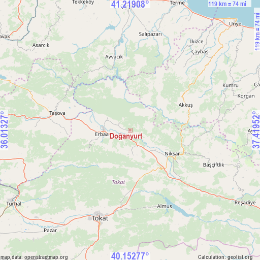
Doğanyurt GPS coordinates[2]
40° 41' 17.016" North, 36° 42' 59.004" East
| Map corner | latitude | longitude |
|---|---|---|
| Upper-left | 41.21908°, | 36.01327° |
| Center: | 40.68806°, | 36.71639° |
| Lower-right: | 40.15277°, | 37.41952° |
| Map W x H: | 118.6×118.6 km | = 73.7×73.7mi |
| max Lat: | 42.02683° ⇑19.3% North |
| Doğanyurt: | 40.68806° |
| min Lat: | ⇓80.7% South 35.9025° |
| min Long | Doğanyurt | max Long |
| 25.90902° | 36.71639° | 44.60099° |
| W 55.8%⇐ | ⇒44.2% E |
Elevation
Elevation of Doğanyurt is 440 m = 1444 ft, and this is 277.4 m = 910 ft below average elevation for this country.
| Max E: |
2682 m = 8799 ft | 63.7% |
| Avg. | 717.4 m = 2354 ft | |
| Doğanyurt | 440 m = 1444 ft | |
Min E: |
0 m = 0 ft | 36.3% |
See also: Turkey elevation on elevation.city.
Geographical zone
Doğanyurt is located in North temperate zone (between Tropic of Cancer and the Arctic Circle). Distance of this Northern Tropic circle is 1918.2 km =1191.9 mi to South.| Distance of | km | miles | from Doğanyurt |
|---|---|---|---|
| North Pole | 5483 | 3407 | to North |
| Arctic Circle | 2877.1 | 1787.7 | to North |
| Tropic Cancer | 1918.2 | 1191.9 | to South |
| Equator | 4524.1 | 2811.1 | to South |


Nearby cities:
15 places around Doğanyurt: (largest is in red/bold)
• Akkuş
27.8 km =17.3 mi,  65°
65°
• Almus
38.2 km =23.7 mi,  155°
155°
• Ayvacık
34.4 km =21.4 mi,  348°
348°
• Başçiftlik
41.3 km =25.7 mi,  112°
112°
• Erbaa
12.7 km =7.9 mi,  260°
260°
• Esençay
28.4 km =17.6 mi,  265°
265°
• Gökdere
24.1 km =15 mi,  172°
172°
• Gökçeli
11.7 km =7.3 mi, 173°
• Karayaka
12.3 km =7.6 mi,  300°
300°
• Kozlu
21.9 km =13.6 mi,  246°
246°
• Niksar
22.6 km =14 mi,  118°
118°
• Taşova
34.1 km =21.2 mi,  283°
283°
• Tekke
44.3 km =27.5 mi, 273°
• Tokat
43.8 km =27.2 mi,  198°
198°
• Çamiçi
25.3 km =15.7 mi, 107°
Sources, notices
• [Note1] Compared only with cities in Turkey existing in our database
• [Src1] Map data: © OpenStreetMap contributors (CC-BY-SA)
• [Src2] Other city data from geonames.org with taken over terms of usage.
• [Src3] Geographical zone / Annual Mean Temperature by Robert A. Rohde @ Wikipedia
