Hayrabolu geodata
Hayrabolu (Tekirdağ) is a seat of a second-order administrative division; located in Turkey in Europe/Istanbul (GMT+3) time zone. With population of 19,793 people, there are 334 cities with bigger population in this country. Compared to other cities in Turkey, 94.3% of cities are located further ↓South; 96.4% of cities are located further →East and 86.2% of cities have higher elevation than Hayrabolu. Note1


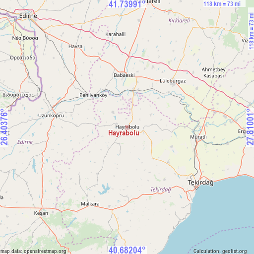
Hayrabolu GPS coordinates[2]
41° 12' 47.196" North, 27° 6' 24.768" East
| Map corner | latitude | longitude |
|---|---|---|
| Upper-left | 41.73991°, | 26.40376° |
| Center: | 41.21311°, | 27.10688° |
| Lower-right: | 40.68204°, | 27.81001° |
| Map W x H: | 117.6×117.6 km | = 73.1×73.1mi |
| max Lat: | 42.02683° ⇑5.7% North |
| Hayrabolu: | 41.21311° |
| min Lat: | ⇓94.3% South 35.9025° |
| min Long | Hayrabolu | max Long |
| 25.90902° | 27.10688° | 44.60099° |
| W 3.6%⇐ | ⇒96.4% E |
Elevation
Elevation of Hayrabolu is 64 m = 210 ft, and this is 653.4 m = 2144 ft below average elevation for this country.
| Max E: |
2682 m = 8799 ft | 86.2% |
| Avg. | 717.4 m = 2354 ft | |
| Hayrabolu | 64 m = 210 ft | |
Min E: |
0 m = 0 ft | 13.8% |
See also: Turkey elevation on elevation.city.
Geographical zone
Hayrabolu is located in North temperate zone (between Tropic of Cancer and the Arctic Circle). Distance of this Northern Tropic circle is 1976.5 km =1228.1 mi to South.| Distance of | km | miles | from Hayrabolu |
|---|---|---|---|
| North Pole | 5424.6 | 3370.7 | to North |
| Arctic Circle | 2818.7 | 1751.5 | to North |
| Tropic Cancer | 1976.5 | 1228.1 | to South |
| Equator | 4582.5 | 2847.4 | to South |


Nearby cities:
15 places around Hayrabolu: (largest is in red/bold)
• Babaeski
24.4 km =15.2 mi,  357°
357°
• Banarlı
25.1 km =15.6 mi,  130°
130°
• Büyükkarıştıran
37.9 km =23.5 mi,  75°
75°
• Dambaslar
11.9 km =7.4 mi, 84°
• Hamidiye
37.7 km =23.4 mi,  259°
259°
• Kırcasalih
32.7 km =20.3 mi,  307°
307°
• Lüleburgaz
29.9 km =18.6 mi,  44°
44°
• Muratlı
33.1 km =20.6 mi,  97°
97°
• Pehlivanköy
21.3 km =13.2 mi, 314°
• Susuzmüsellim
13.1 km =8.1 mi,  194°
194°
• Uzunköprü
35.5 km =22.1 mi,  279°
279°
• Yürük
31.1 km =19.3 mi, 186°
• Çöpköy
23.8 km =14.8 mi,  271°
271°
• İnecik
34.2 km =21.3 mi,  154°
154°
• Şahin
30.7 km =19.1 mi,  226°
226°
Sources, notices
• [Note1] Compared only with cities in Turkey existing in our database
• [Src1] Map data: © OpenStreetMap contributors (CC-BY-SA)
• [Src2] Other city data from geonames.org with taken over terms of usage.
• [Src3] Geographical zone / Annual Mean Temperature by Robert A. Rohde @ Wikipedia
