Muratlı geodata
Muratlı (Tekirdağ) is a seat of a second-order administrative division; located in Turkey in Europe/Istanbul (GMT+3) time zone. In our database, there are 1323 cities with bigger population. Compared to other cities in Turkey, 93.5% of cities are located further ↓South; 93.6% of cities are located further →East and 83.3% of cities have higher elevation than Muratlı. Note1


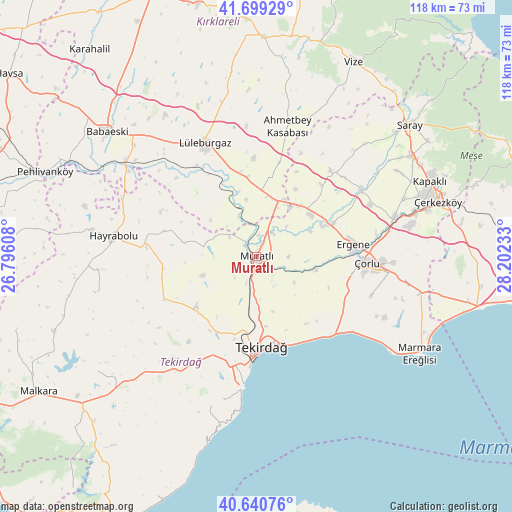
Muratlı GPS coordinates[2]
41° 10' 19.776" North, 27° 29' 57.12" East
| Map corner | latitude | longitude |
|---|---|---|
| Upper-left | 41.69929°, | 26.79608° |
| Center: | 41.17216°, | 27.4992° |
| Lower-right: | 40.64076°, | 28.20233° |
| Map W x H: | 117.7×117.7 km | = 73.1×73.1mi |
| max Lat: | 42.02683° ⇑6.5% North |
| Muratlı: | 41.17216° |
| min Lat: | ⇓93.5% South 35.9025° |
| min Long | Muratlı | max Long |
| 25.90902° | 27.4992° | 44.60099° |
| W 6.4%⇐ | ⇒93.6% E |
Elevation
Elevation of Muratlı is 84 m = 276 ft, and this is 633.4 m = 2078 ft below average elevation for this country.
| Max E: |
2682 m = 8799 ft | 83.3% |
| Avg. | 717.4 m = 2354 ft | |
| Muratlı | 84 m = 276 ft | |
Min E: |
0 m = 0 ft | 16.7% |
See also: Turkey elevation on elevation.city.
Geographical zone
Muratlı is located in North temperate zone (between Tropic of Cancer and the Arctic Circle). Distance of this Northern Tropic circle is 1972 km =1225.3 mi to South.| Distance of | km | miles | from Muratlı |
|---|---|---|---|
| North Pole | 5429.1 | 3373.5 | to North |
| Arctic Circle | 2823.3 | 1754.3 | to North |
| Tropic Cancer | 1972 | 1225.3 | to South |
| Equator | 4577.9 | 2844.6 | to South |


Nearby cities:
15 places around Muratlı: (largest is in red/bold)
• Banarlı
18 km =11.2 mi,  229°
229°
• Beyazköy
26 km =16.2 mi,  41°
41°
• Büyükkarıştıran
14.8 km =9.2 mi,  15°
15°
• Dambaslar
21.8 km =13.5 mi,  285°
285°
• Hayrabolu
33.1 km =20.6 mi,  277°
277°
• Kapaklı
43.9 km =27.3 mi,  66°
66°
• Kumbağ
32.4 km =20.1 mi,  185°
185°
• Lüleburgaz
28.3 km =17.6 mi,  335°
335°
• Marmaracık
21.7 km =13.5 mi,  79°
79°
• Susuzmüsellim
37.1 km =23.1 mi,  257°
257°
• Tekirdağ
21.6 km =13.4 mi,  177°
177°
• Velimeşe
33 km =20.5 mi, 74°
• Çerkezköy
43.7 km =27.2 mi, 73°
• Çorlu
25.2 km =15.7 mi,  93°
93°
• İnecik
32.1 km =19.9 mi,  214°
214°
Sources, notices
• [Note1] Compared only with cities in Turkey existing in our database
• [Src1] Map data: © OpenStreetMap contributors (CC-BY-SA)
• [Src2] Other city data from geonames.org with taken over terms of usage.
• [Src3] Geographical zone / Annual Mean Temperature by Robert A. Rohde @ Wikipedia
