Kızılcahamam geodata
Kızılcahamam (Ankara) is a seat of a second-order administrative division; located in Turkey in Europe/Istanbul (GMT+3) time zone. With population of 17,975 people, there are 352 cities with bigger population in this country. Compared to other cities in Turkey, 77% of cities are located further ↓South; 63.7% of cities are located further →East and 66.5% of cities have lower elevation than Kızılcahamam. Note1


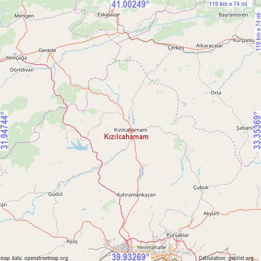
Kızılcahamam GPS coordinates[2]
40° 28' 10.992" North, 32° 39' 2.016" East
| Map corner | latitude | longitude |
|---|---|---|
| Upper-left | 41.00249°, | 31.94744° |
| Center: | 40.46972°, | 32.65056° |
| Lower-right: | 39.93269°, | 33.35369° |
| Map W x H: | 119×118.9 km | = 73.9×73.9mi |
| max Lat: | 42.02683° ⇑23% North |
| Kızılcahamam: | 40.46972° |
| min Lat: | ⇓77% South 35.9025° |
| min Long | Kızılcahamam | max Long |
| 25.90902° | 32.65056° | 44.60099° |
| W 36.3%⇐ | ⇒63.7% E |
Elevation
Elevation of Kızılcahamam is 980 m = 3215 ft, and this is 262.6 m = 862 ft above average elevation for this country.
| Max E: |
2682 m = 8799 ft | 33.5% |
| Kızılcahamam | 980 m 3215 ft | |
| Avg. | 717.4 m = 2354 ft | |
Min E: |
0 m = 0 ft | 66.5% |
See also: Turkey elevation on elevation.city.
Geographical zone
Kızılcahamam is located in North temperate zone (between Tropic of Cancer and the Arctic Circle). Distance of this Northern Tropic circle is 1893.9 km =1176.8 mi to South.| Distance of | km | miles | from Kızılcahamam |
|---|---|---|---|
| North Pole | 5507.3 | 3422.1 | to North |
| Arctic Circle | 2901.4 | 1802.8 | to North |
| Tropic Cancer | 1893.9 | 1176.8 | to South |
| Equator | 4499.8 | 2796 | to South |


Nearby cities:
15 places around Kızılcahamam: (largest is in red/bold)
• Akyurt
52.4 km =32.6 mi,  135°
135°
• Atkaracalar
52.6 km =32.7 mi,  42°
42°
• Gözyeri
45 km =28 mi,  348°
348°
• Güdül
44.8 km =27.8 mi,  229°
229°
• Güvem
13.5 km =8.4 mi,  3°
3°
• Kazan
26.6 km =16.5 mi,  173°
173°
• Orta
42.4 km =26.3 mi,  66°
66°
• Pazar
17.6 km =10.9 mi,  151°
151°
• Peçenek
29.5 km =18.3 mi,  258°
258°
• Pursaklar
52.9 km =32.9 mi,  156°
156°
• Uruş
49.9 km =31 mi,  240°
240°
• Çamlıdere
15 km =9.3 mi,  278°
278°
• Çeltikçi
23.3 km =14.5 mi, 225°
• Çerkeş
43.2 km =26.8 mi,  28°
28°
• Çubuk
41.3 km =25.7 mi,  128°
128°
Sources, notices
• [Note1] Compared only with cities in Turkey existing in our database
• [Src1] Map data: © OpenStreetMap contributors (CC-BY-SA)
• [Src2] Other city data from geonames.org with taken over terms of usage.
• [Src3] Geographical zone / Annual Mean Temperature by Robert A. Rohde @ Wikipedia
