Uruş geodata
Uruş (Ankara) is a seat of a third-order administrative division; located in Turkey in Europe/Istanbul (GMT+3) time zone. In our database, there are 1323 cities with bigger population. Compared to other cities in Turkey, 73.6% of cities are located further ↓South; 66% of cities are located further →East and 57.1% of cities have lower elevation than Uruş. Note1


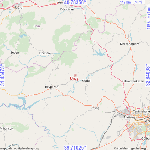
Uruş GPS coordinates[2]
40° 14' 56.508" North, 32° 8' 16.26" East
| Map corner | latitude | longitude |
|---|---|---|
| Upper-left | 40.78356°, | 31.43473° |
| Center: | 40.24903°, | 32.13785° |
| Lower-right: | 39.71025°, | 32.84098° |
| Map W x H: | 119.3×119.3 km | = 74.1×74.1mi |
| max Lat: | 42.02683° ⇑26.4% North |
| Uruş: | 40.24903° |
| min Lat: | ⇓73.6% South 35.9025° |
| min Long | Uruş | max Long |
| 25.90902° | 32.13785° | 44.60099° |
| W 34%⇐ | ⇒66% E |
Elevation
Elevation of Uruş is 827 m = 2713 ft, and this is 109.6 m = 360 ft above average elevation for this country.
| Max E: |
2682 m = 8799 ft | 42.9% |
| Uruş | 827 m 2713 ft | |
| Avg. | 717.4 m = 2354 ft | |
Min E: |
0 m = 0 ft | 57.1% |
See also: Turkey elevation on elevation.city.
Geographical zone
Uruş is located in North temperate zone (between Tropic of Cancer and the Arctic Circle). Distance of this Northern Tropic circle is 1869.4 km =1161.6 mi to South.| Distance of | km | miles | from Uruş |
|---|---|---|---|
| North Pole | 5531.8 | 3437.3 | to North |
| Arctic Circle | 2925.9 | 1818.1 | to North |
| Tropic Cancer | 1869.4 | 1161.6 | to South |
| Equator | 4475.3 | 2780.8 | to South |


Nearby cities:
15 places around Uruş: (largest is in red/bold)
• Ayaş
30.4 km =18.9 mi,  147°
147°
• Beypazarı
20.5 km =12.7 mi,  243°
243°
• Dörtdivan
52.8 km =32.8 mi,  353°
353°
• Gelegra
36.9 km =22.9 mi,  224°
224°
• Güdül
10.1 km =6.3 mi,  115°
115°
• Karaşar
15.4 km =9.6 mi,  303°
303°
• Kazan
46.4 km =28.8 mi,  92°
92°
• Kıbrıscık
30 km =18.6 mi,  306°
306°
• Kızılcahamam
49.9 km =31 mi,  60°
60°
• Pazar
52.5 km =32.6 mi,  80°
80°
• Peçenek
23.8 km =14.8 mi,  37°
37°
• Seben
51.1 km =31.8 mi,  290°
290°
• Çamlıdere
39.1 km =24.3 mi,  46°
46°
• Çayırhan
42.9 km =26.7 mi,  246°
246°
• Çeltikçi
28.2 km =17.5 mi,  73°
73°
Sources, notices
• [Note1] Compared only with cities in Turkey existing in our database
• [Src1] Map data: © OpenStreetMap contributors (CC-BY-SA)
• [Src2] Other city data from geonames.org with taken over terms of usage.
• [Src3] Geographical zone / Annual Mean Temperature by Robert A. Rohde @ Wikipedia
