Çerkeş geodata
Çerkeş (Çankırı) is a seat of a second-order administrative division; located in Turkey in Europe/Istanbul (GMT+3) time zone. With population of 17,802 people, there are 353 cities with bigger population in this country. Compared to other cities in Turkey, 83.9% of cities are located further ↓South; 62.5% of cities are located further →East and 76.6% of cities have lower elevation than Çerkeş. Note1


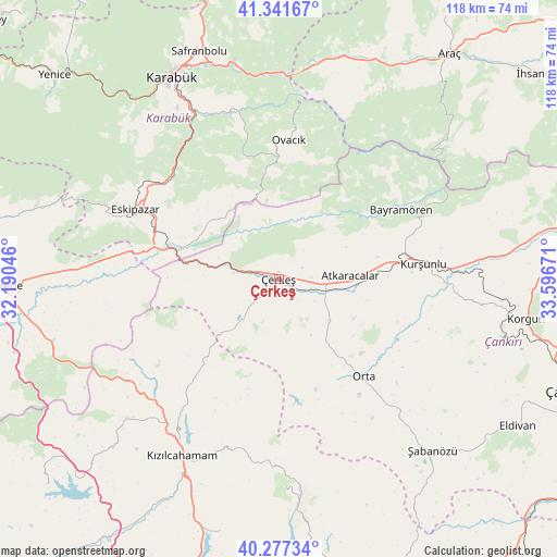
Çerkeş GPS coordinates[2]
40° 48' 41.904" North, 32° 53' 36.888" East
| Map corner | latitude | longitude |
|---|---|---|
| Upper-left | 41.34167°, | 32.19046° |
| Center: | 40.81164°, | 32.89358° |
| Lower-right: | 40.27734°, | 33.59671° |
| Map W x H: | 118.3×118.3 km | = 73.5×73.5mi |
| max Lat: | 42.02683° ⇑16.1% North |
| Çerkeş: | 40.81164° |
| min Lat: | ⇓83.9% South 35.9025° |
| min Long | Çerkeş | max Long |
| 25.90902° | 32.89358° | 44.60099° |
| W 37.5%⇐ | ⇒62.5% E |
Elevation
Elevation of Çerkeş is 1133 m = 3717 ft, and this is 415.6 m = 1364 ft above average elevation for this country.
| Max E: |
2682 m = 8799 ft | 23.4% |
| Çerkeş | 1133 m 3717 ft | |
| Avg. | 717.4 m = 2354 ft | |
Min E: |
0 m = 0 ft | 76.6% |
See also: Turkey elevation on elevation.city.
Geographical zone
Çerkeş is located in North temperate zone (between Tropic of Cancer and the Arctic Circle). Distance of this Northern Tropic circle is 1931.9 km =1200.4 mi to South.| Distance of | km | miles | from Çerkeş |
|---|---|---|---|
| North Pole | 5469.2 | 3398.4 | to North |
| Arctic Circle | 2863.3 | 1779.2 | to North |
| Tropic Cancer | 1931.9 | 1200.4 | to South |
| Equator | 4537.8 | 2819.7 | to South |


Nearby cities:
15 places around Çerkeş: (largest is in red/bold)
• Atkaracalar
15.3 km =9.5 mi,  88°
88°
• Bayramören
29.8 km =18.5 mi,  60°
60°
• Belören
50.9 km =31.6 mi,  83°
83°
• Boyalı
42 km =26.1 mi, 55°
• Eskipazar
33.8 km =21 mi,  295°
295°
• Gözyeri
30.2 km =18.8 mi,  281°
281°
• Güvem
31.4 km =19.5 mi,  218°
218°
• Karabük
49.1 km =30.5 mi,  332°
332°
• Kurşunlu
31 km =19.3 mi, 83°
• Kızılcahamam
43.2 km =26.8 mi,  208°
208°
• Orta
27.7 km =17.2 mi,  138°
138°
• Ovacık
29.5 km =18.3 mi,  4°
4°
• Çamlıdere
50.3 km =31.3 mi, 224°
• İğdir
50.4 km =31.3 mi,  23°
23°
• Şabanözü
49.2 km =30.6 mi, 138°
Sources, notices
• [Note1] Compared only with cities in Turkey existing in our database
• [Src1] Map data: © OpenStreetMap contributors (CC-BY-SA)
• [Src2] Other city data from geonames.org with taken over terms of usage.
• [Src3] Geographical zone / Annual Mean Temperature by Robert A. Rohde @ Wikipedia
