Seçköy geodata
Seçköy (Bursa) is a populated place; located in Turkey in Europe/Istanbul (GMT+3) time zone. With population of 771 people, there are 1167 cities with bigger population in this country. Compared to other cities in Turkey, 74.7% of cities are located further ↓South; 81.9% of cities are located further →East and 63.1% of cities have higher elevation than Seçköy. Note1


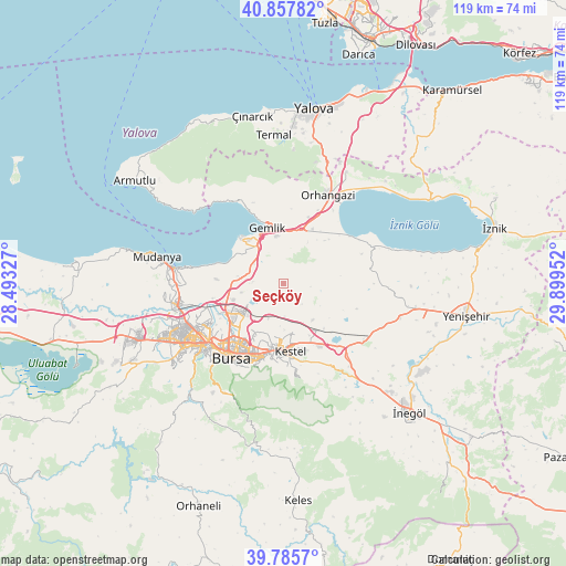
Seçköy GPS coordinates[2]
40° 19' 26.004" North, 29° 11' 47.004" East
| Map corner | latitude | longitude |
|---|---|---|
| Upper-left | 40.85782°, | 28.49327° |
| Center: | 40.32389°, | 29.19639° |
| Lower-right: | 39.7857°, | 29.89952° |
| Map W x H: | 119.2×119.2 km | = 74.1×74.1mi |
| max Lat: | 42.02683° ⇑25.3% North |
| Seçköy: | 40.32389° |
| min Lat: | ⇓74.7% South 35.9025° |
| min Long | Seçköy | max Long |
| 25.90902° | 29.19639° | 44.60099° |
| W 18.1%⇐ | ⇒81.9% E |
Elevation
Elevation of Seçköy is 448 m = 1470 ft, and this is 269.4 m = 884 ft below average elevation for this country.
| Max E: |
2682 m = 8799 ft | 63.1% |
| Avg. | 717.4 m = 2354 ft | |
| Seçköy | 448 m = 1470 ft | |
Min E: |
0 m = 0 ft | 36.9% |
See also: Turkey elevation on elevation.city.
Geographical zone
Seçköy is located in North temperate zone (between Tropic of Cancer and the Arctic Circle). Distance of this Northern Tropic circle is 1877.7 km =1166.7 mi to South.| Distance of | km | miles | from Seçköy |
|---|---|---|---|
| North Pole | 5523.5 | 3432.1 | to North |
| Arctic Circle | 2917.6 | 1812.9 | to North |
| Tropic Cancer | 1877.7 | 1166.7 | to South |
| Equator | 4483.6 | 2786 | to South |


Nearby cities:
15 places around Seçköy: (largest is in red/bold)
• Bursa
18.4 km =11.4 mi,  219°
219°
• Demirtaş
10.1 km =6.3 mi,  235°
235°
• Gemlik
12.3 km =7.6 mi,  345°
345°
• Gölcük
16.3 km =10.1 mi,  108°
108°
• Gürsu
11.7 km =7.3 mi,  180°
180°
• Karacaali
20.4 km =12.7 mi,  327°
327°
• Kestel
14 km =8.7 mi,  174°
174°
• Kozluören
25.7 km =16 mi,  148°
148°
• Küçükkumla
18.2 km =11.3 mi, 333°
• Narlıca
25.1 km =15.6 mi,  74°
74°
• Orhangazi
20.7 km =12.9 mi,  27°
27°
• Osmangazi
18.3 km =11.4 mi, 219°
• Sölöz
20.2 km =12.6 mi, 66°
• Umurbey
10.2 km =6.3 mi, 353°
• Yıldırım
16.8 km =10.4 mi,  206°
206°
Sources, notices
• [Note1] Compared only with cities in Turkey existing in our database
• [Src1] Map data: © OpenStreetMap contributors (CC-BY-SA)
• [Src2] Other city data from geonames.org with taken over terms of usage.
• [Src3] Geographical zone / Annual Mean Temperature by Robert A. Rohde @ Wikipedia
