Bursa geodata
Bursa is a seat of a first-order administrative division; located in Turkey in Europe/Istanbul (GMT+3) time zone. With population of 1,412,701 people, there are 3 cities with bigger population in this country. Compared to other cities in Turkey, 72.4% of cities are located further ↓South; 83.5% of cities are located further →East and 76.4% of cities have higher elevation than Bursa. Note1


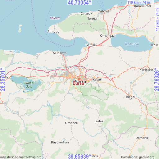
Bursa GPS coordinates[2]
40° 11' 44.124" North, 29° 3' 36.468" East
| Map corner | latitude | longitude |
|---|---|---|
| Upper-left | 40.73054°, | 28.35701° |
| Center: | 40.19559°, | 29.06013° |
| Lower-right: | 39.65639°, | 29.76326° |
| Map W x H: | 119.4×119.4 km | = 74.2×74.2mi |
| max Lat: | 42.02683° ⇑27.6% North |
| Bursa: | 40.19559° |
| min Lat: | ⇓72.4% South 35.9025° |
| min Long | Bursa | max Long |
| 25.90902° | 29.06013° | 44.60099° |
| W 16.5%⇐ | ⇒83.5% E |
Elevation
Elevation of Bursa is 155 m = 509 ft, and this is 562.4 m = 1845 ft below average elevation for this country.
| Max E: |
2682 m = 8799 ft | 76.4% |
| Avg. | 717.4 m = 2354 ft | |
| Bursa | 155 m = 509 ft | |
Min E: |
0 m = 0 ft | 23.6% |
See also: Bursa elevation on elevation.city.
Geographical zone
Bursa is located in North temperate zone (between Tropic of Cancer and the Arctic Circle). Distance of this Northern Tropic circle is 1863.4 km =1157.9 mi to South.| Distance of | km | miles | from Bursa |
|---|---|---|---|
| North Pole | 5537.7 | 3441 | to North |
| Arctic Circle | 2931.8 | 1821.7 | to North |
| Tropic Cancer | 1863.4 | 1157.9 | to South |
| Equator | 4469.3 | 2777.1 | to South |


Nearby cities:
15 places around Bursa: (largest is in red/bold)
• Demirtaş
9.1 km =5.7 mi,  20°
20°
• Gemlik
27.5 km =17.1 mi, 17°
• Görükle
19.1 km =11.9 mi,  281°
281°
• Gürsu
11.7 km =7.3 mi,  77°
77°
• Kestel
12.9 km =8 mi,  88°
88°
• Kirazlı
10.8 km =6.7 mi,  188°
188°
• Kozluören
26 km =16.2 mi,  107°
107°
• Mudanya
25 km =15.5 mi,  322°
322°
• Nilüfer
12.4 km =7.7 mi, 279°
• Osmangazi
0.1 km =0.1 mi,  331°
331°
• Seçköy
18.4 km =11.4 mi,  39°
39°
• Soğukpınar
16.5 km =10.3 mi,  161°
161°
• Umurbey
26.5 km =16.5 mi, 23°
• Yıldırım
4.3 km =2.7 mi,  100°
100°
• Çalı
12.2 km =7.6 mi,  255°
255°
Sources, notices
• [Note1] Compared only with cities in Turkey existing in our database
• [Src1] Map data: © OpenStreetMap contributors (CC-BY-SA)
• [Src2] Other city data from geonames.org with taken over terms of usage.
• [Src3] Geographical zone / Annual Mean Temperature by Robert A. Rohde @ Wikipedia
