Çat geodata
Çat (Kocaeli) is a populated place; located in Turkey in Europe/Istanbul (GMT+3) time zone. With population of 779 people, there are 1161 cities with bigger population in this country. Compared to other cities in Turkey, 87.9% of cities are located further ↓South; 77.1% of cities are located further →East and 73.6% of cities have higher elevation than Çat. Note1


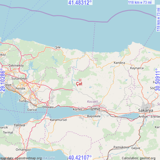
Çat GPS coordinates[2]
40° 57' 15.228" North, 29° 48' 21.528" East
| Map corner | latitude | longitude |
|---|---|---|
| Upper-left | 41.48312°, | 29.10286° |
| Center: | 40.95423°, | 29.80598° |
| Lower-right: | 40.42107°, | 30.50911° |
| Map W x H: | 118.1×118.1 km | = 73.4×73.4mi |
| max Lat: | 42.02683° ⇑12.1% North |
| Çat: | 40.95423° |
| min Lat: | ⇓87.9% South 35.9025° |
| min Long | Çat | max Long |
| 25.90902° | 29.80598° | 44.60099° |
| W 22.9%⇐ | ⇒77.1% E |
Elevation
Elevation of Çat is 199 m = 653 ft, and this is 518.4 m = 1701 ft below average elevation for this country.
| Max E: |
2682 m = 8799 ft | 73.6% |
| Avg. | 717.4 m = 2354 ft | |
| Çat | 199 m = 653 ft | |
Min E: |
0 m = 0 ft | 26.4% |
See also: Turkey elevation on elevation.city.
Geographical zone
Çat is located in North temperate zone (between Tropic of Cancer and the Arctic Circle). Distance of this Northern Tropic circle is 1947.8 km =1210.3 mi to South.| Distance of | km | miles | from Çat |
|---|---|---|---|
| North Pole | 5453.4 | 3388.6 | to North |
| Arctic Circle | 2847.5 | 1769.4 | to North |
| Tropic Cancer | 1947.8 | 1210.3 | to South |
| Equator | 4553.7 | 2829.5 | to South |


Nearby cities:
15 places around Çat: (largest is in red/bold)
• Akçaova
12.2 km =7.6 mi,  41°
41°
• Ağva
20.9 km =13 mi,  11°
11°
• Derince
21.9 km =13.6 mi,  178°
178°
• Değirmendere
26.1 km =16.2 mi, 184°
• Gölcük
28.5 km =17.7 mi,  168°
168°
• Halıdere
26.9 km =16.7 mi,  189°
189°
• Hereke
24.7 km =15.3 mi,  220°
220°
• Karacaköy
22.1 km =13.7 mi,  352°
352°
• Körfez
20.9 km =13 mi, 185°
• Köseköy
29.1 km =18.1 mi,  144°
144°
• Mollafeneri
27.2 km =16.9 mi,  253°
253°
• Tavşancıl
28.3 km =17.6 mi, 223°
• Tavşanlı
29 km =18 mi,  238°
238°
• Teke
17.4 km =10.8 mi,  312°
312°
• İzmit
23.5 km =14.6 mi,  153°
153°
Sources, notices
• [Note1] Compared only with cities in Turkey existing in our database
• [Src1] Map data: © OpenStreetMap contributors (CC-BY-SA)
• [Src2] Other city data from geonames.org with taken over terms of usage.
• [Src3] Geographical zone / Annual Mean Temperature by Robert A. Rohde @ Wikipedia
