Akçaova geodata
Akçaova (Kocaeli) is a seat of a third-order administrative division; located in Turkey in Europe/Istanbul (GMT+3) time zone. In our database, there are 1323 cities with bigger population. Compared to other cities in Turkey, 90.6% of cities are located further ↓South; 76.5% of cities are located further →East and 83.3% of cities have higher elevation than Akçaova. Note1


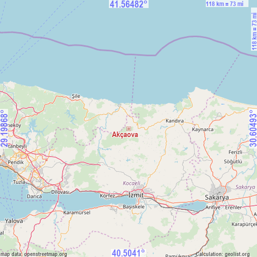
Akçaova GPS coordinates[2]
41° 2' 11.76" North, 29° 54' 6.48" East
| Map corner | latitude | longitude |
|---|---|---|
| Upper-left | 41.56482°, | 29.19868° |
| Center: | 41.0366°, | 29.9018° |
| Lower-right: | 40.5041°, | 30.60493° |
| Map W x H: | 117.9×117.9 km | = 73.3×73.3mi |
| max Lat: | 42.02683° ⇑9.4% North |
| Akçaova: | 41.0366° |
| min Lat: | ⇓90.6% South 35.9025° |
| min Long | Akçaova | max Long |
| 25.90902° | 29.9018° | 44.60099° |
| W 23.5%⇐ | ⇒76.5% E |
Elevation
Elevation of Akçaova is 84 m = 276 ft, and this is 633.4 m = 2078 ft below average elevation for this country.
| Max E: |
2682 m = 8799 ft | 83.3% |
| Avg. | 717.4 m = 2354 ft | |
| Akçaova | 84 m = 276 ft | |
Min E: |
0 m = 0 ft | 16.7% |
See also: Turkey elevation on elevation.city.
Geographical zone
Akçaova is located in North temperate zone (between Tropic of Cancer and the Arctic Circle). Distance of this Northern Tropic circle is 1956.9 km =1216 mi to South.| Distance of | km | miles | from Akçaova |
|---|---|---|---|
| North Pole | 5444.2 | 3382.9 | to North |
| Arctic Circle | 2838.3 | 1763.6 | to North |
| Tropic Cancer | 1956.9 | 1216 | to South |
| Equator | 4562.8 | 2835.2 | to South |


Nearby cities:
15 places around Akçaova: (largest is in red/bold)
• Akmeşe
32.5 km =20.2 mi,  129°
129°
• Ağva
11.9 km =7.4 mi,  341°
341°
• Derince
31.9 km =19.8 mi,  193°
193°
• Kandıra
21.4 km =13.3 mi,  79°
79°
• Karacaköy
16.9 km =10.5 mi,  318°
318°
• Kaymas
33.1 km =20.6 mi,  112°
112°
• Kaynarca
34 km =21.1 mi,  91°
91°
• Kefken
31.1 km =19.3 mi,  61°
61°
• Kullar
35.5 km =22.1 mi,  168°
168°
• Körfez
31.6 km =19.6 mi,  198°
198°
• Köseköy
34.1 km =21.2 mi, 165°
• Teke
21 km =13 mi,  277°
277°
• Çat
12.2 km =7.6 mi,  221°
221°
• İzmit
30.3 km =18.8 mi,  175°
175°
• Şile
28.7 km =17.8 mi,  302°
302°
Sources, notices
• [Note1] Compared only with cities in Turkey existing in our database
• [Src1] Map data: © OpenStreetMap contributors (CC-BY-SA)
• [Src2] Other city data from geonames.org with taken over terms of usage.
• [Src3] Geographical zone / Annual Mean Temperature by Robert A. Rohde @ Wikipedia
